Photos • Location

An old fort with small holes for manual Brno guns

An artificial lake made from underground
qanats

A garden
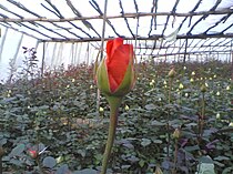
A rose garden

Dogs used to protect sheep from mountain wolves

A small pool for fish

Pandar Jan
پندرجان | |
|---|---|
village | |
 Pandar Jan | |
| Coordinates: 33°49′32″N 50°04′32″E / 33.82556°N 50.07556°E | |
| Country | |
| Province | Markazi |
| County | Khomeyn |
| Bakhsh | Central |
| Rural District | Hamzehlu |
| Population (2006) | |
| • Total | 67 |
| Time zone | UTC+3:30 ( IRST) |
| • Summer ( DST) | UTC+4:30 ( IRDT) |
Pandar Jan ( Persian: پندرجان, also romanized as Pandar Jān, Penderjān, Pender John, and Penderjohn) [1] is a village in Hamzehlu Rural District, in the Central District of Khomeyn County, Markazi Province, Iran. At the 2006 census, its population was 67, in 18 families. [2]


References
- ^ Pandar Jan can be found at GEOnet Names Server, at this link, by opening the Advanced Search box, entering "-3077762" in the "Unique Feature Id" form, and clicking on "Search Database".
- ^ "Census of the Islamic Republic of Iran, 1385 (2006)" (Excel). Statistical Center of Iran. Archived from the original on 2011-09-20.
| Capital | |||||||||||||||||||||||||||
|---|---|---|---|---|---|---|---|---|---|---|---|---|---|---|---|---|---|---|---|---|---|---|---|---|---|---|---|
| Districts |
| ||||||||||||||||||||||||||
|
| This Khomeyn County location article is a stub. You can help Wikipedia by expanding it. |