Photos • Location


Oudon | |
|---|---|
Commune | |
 The 14th century tower of the
Château d'Oudon | |
 Coat of arms | |
 Oudon  Oudon | |
| Coordinates: 47°20′50″N 1°17′09″W / 47.3472°N 1.2858°W | |
| Country | France |
| Region | Pays de la Loire |
| Department | Loire-Atlantique |
| Arrondissement | Châteaubriant-Ancenis |
| Canton | Ancenis-Saint-Géréon |
| Intercommunality | Pays d'Ancenis |
| Government | |
| • Mayor (2020–2026) | Alain Bourgoin [1] |
| Area 1 | 22.12 km2 (8.54 sq mi) |
| Population (2021)
[2] | 3,925 |
| • Density | 180/km2 (460/sq mi) |
| Time zone | UTC+01:00 ( CET) |
| • Summer ( DST) | UTC+02:00 ( CEST) |
| INSEE/Postal code |
44115 /44521 |
| Elevation | 2–74 m (6.6–242.8 ft) |
| 1 French Land Register data, which excludes lakes, ponds, glaciers > 1 km2 (0.386 sq mi or 247 acres) and river estuaries. | |
Oudon (French pronunciation: [udɔ̃] ) is a commune in the Loire-Atlantique department in western France.
Population
|
| ||||||||||||||||||||||||||||||||||||||||||||||||||||||
| Source: EHESS [3] and INSEE (1968-2017) [4] | |||||||||||||||||||||||||||||||||||||||||||||||||||||||
Gallery
-
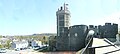 Oudon Castle
 -
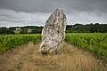 Menhir of "Pierre blanche"


Town twinning
References
- ^ "Répertoire national des élus: les maires" (in French). data.gouv.fr, Plateforme ouverte des données publiques françaises. 13 September 2022.
- ^ "Populations légales 2021" (in French). The National Institute of Statistics and Economic Studies. 28 December 2023.
- ^ Des villages de Cassini aux communes d'aujourd'hui: Commune data sheet Oudon, EHESS (in French).
- ^ Population en historique depuis 1968, INSEE
See also
Wikimedia Commons has media related to
Oudon.
| International | |
|---|---|
| National | |
|
| This Loire-Atlantique geographical article is a stub. You can help Wikipedia by expanding it. |