Photos • Location
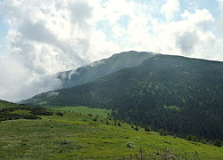
Babia Góra, a mountain in the range


(Redirected from
Orava Beskids)

Oravské Beskydy ( Hungarian: Árvai-Beszkidek) is a range of mountains straddling the northern- Slovakia-southern- Poland border, considered part of the Central Beskids, within the Outer Western Carpathians. [1]
The highest mountain of the range is Babia Góra (1,725 metres [5,659 ft]), the center of the Babia Góra National Park, one of the first biosphere reserves established worldwide.
References
- ^ "TuristickaMapa.sk – turistická mapa Slovenska". TURISTICKAMAPA.SK (in Slovak). Retrieved 20 August 2022.
Wikimedia Commons has media related to
Oravské Beskydy.
49°34′24″N 19°31′47″E / 49.5732°N 19.5296°E
| Authority control databases: National |
|---|