Photos • Location
Olszyniec | |
|---|---|
Village | |
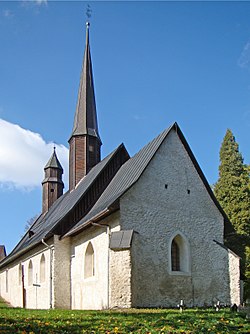
 Saints Joachim and Anna Church | |
| Coordinates: 50°43′36″N 16°23′0″E / 50.72667°N 16.38333°E | |
| Country | |
| Voivodeship | Lower Silesian |
| County | Wałbrzych |
| Gmina | Walim |
| Population (2011
[1]) | 295 |
| Time zone | UTC+1 ( CET) |
| • Summer ( DST) | UTC+2 ( CEST) |
| Area code | +48 74 |
| Vehicle registration | DBA |
Olszyniec [ɔlˈʂɨɲɛt͡s] is a village in the administrative district of Gmina Walim, within Wałbrzych County, Lower Silesian Voivodeship, in south-western Poland. [2]
It lies approximately 6 kilometres (4 mi) north-west of Walim, 10 km (6 mi) south-east of Wałbrzych, and 64 km (40 mi) south-west of the regional capital Wrocław.
During World War II, Germans established a sub-camp of the Gross-Rosen concentration camp in the village. [3]
- ^ "Wieś Olszyniec (dolnośląskie)". Polska w liczbach (in Polish). Retrieved 25 November 2019.
- ^ "Central Statistical Office (GUS) – TERYT (National Register of Territorial Land Apportionment Journal)" (in Polish). 2008-06-01.
- ^ Abraham Kajzer, Za drutami śmierci, Muzeum Gross-Rosen, Wałbrzych, 2013 (in Polish)

