Photos • Location


Niederberndorf | |
|---|---|
 | |
 Niederberndorf  Niederberndorf | |
| Coordinates: 51°11′43″N 8°13′17″E / 51.19528°N 8.22139°E | |
| Country | Germany |
| State | North Rhine-Westphalia |
| Admin. region | Arnsberg |
| District | Hochsauerlandkreis |
| Town | Schmallenberg |
| Population (2021-12-31) | |
| • Total | 205 |
| Time zone | UTC+01:00 ( CET) |
| • Summer ( DST) | UTC+02:00 ( CEST) |
Niederberndorf is a locality in the municipality Schmallenberg in the High Sauerland District in North Rhine-Westphalia, Germany.
The village has 205 inhabitants [1] and lies in the north of the municipality of Schmallenberg at a height of around 341 m. In the village centre the river Arpe flows in the Wenne and the Kreisstraße 35 meets the Kreisstraße 32.
Niederberndorn borders on the villages of Arpe, Landenbeckerbruch, Menkhausen, Mailar, Heiminghausen, Berghausen and Oberberndorf. The St. Blaise Chapel in the village center was first mentioned in 1402.
Gallery
-
 „Nederen Berentrup“ 1645 - Westphalia Ducatus (Duchy of Westphalia)
 -
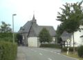 Saint Blaise Chapel in Niederberndorf


References
- ^ Schmallenberg.de: Inhabitants (in German)
Wikimedia Commons has media related to
Niederberndorf.
| International | |
|---|---|
| National | |