Photos • Location
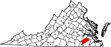
Location of Sussex County in Virginia


This is a list of the National Register of Historic Places listings in Sussex County, Virginia.
This is intended to be a complete list of the properties and districts on the National Register of Historic Places in Sussex County, Virginia, United States. The locations of National Register properties and districts for which the latitude and longitude coordinates are included below, may be seen in an online map. [1]
There are 10 properties and districts listed on the National Register in the county.
This
National Park Service list is complete through
NPS recent listings posted June 14, 2024.
[2]
Current listings
| [3] | Name on the Register [4] | Image | Date listed [5] | Location | City or town | Description |
|---|---|---|---|---|---|---|
| 1 | Miles B. Carpenter House |  |
November 13, 1989 ( #89001920) |
U.S. Route 460 37°02′17″N 77°05′38″W / 37.038056°N 77.093889°W | Waverly | |
| 2 | Chester |  |
December 18, 1970 ( #70000829) |
North of the junction of
State Route 35 and Newville Rd. 36°58′19″N 77°10′46″W / 36.972083°N 77.179444°W | Homeville | |
| 3 | Purnell Fleetwood House |  |
February 25, 2020 ( #100005007) |
202 E. Main St. 37°02′16″N 77°05′30″W / 37.037778°N 77.091667°W | Waverly | |
| 4 | Fortsville |  |
September 15, 1970 ( #70000828) |
Southeast of the junction of Grizzard and Fortsville Rds. 36°42′49″N 77°25′08″W / 36.713611°N 77.418889°W | Grizzard | Straddles the border with Southampton County |
| 5 | Glenview |  |
November 26, 2008 ( #08001114) |
13098 Comans Well Rd. 36°52′15″N 77°24′19″W / 36.870833°N 77.405278°W | Stony Creek | |
| 6 | Hunting Quarter |  |
April 7, 1995 ( #95000396) |
Hunting Quarter Rd., south of its junction with Poole Rd. 36°52′08″N 77°13′26″W / 36.868750°N 77.223889°W | Waverly | |
| 7 | Little Town |  |
November 18, 1976 ( #76002124) |
West of Littleton on Cool Spring Rd. 36°54′25″N 77°10′17″W / 36.906944°N 77.171389°W | Littleton | |
| 8 | Nottoway Archeological Site (44SX6, 44SX7, 44SX98, 44SX162) |  |
November 3, 1988 ( #88002181) |
Address Restricted | Stony Creek | |
| 9 | Sussex County Courthouse Historic District | ,_Sussex,_Virginia.jpg) |
July 24, 1973 ( #73002066) |
Junction of Courthouse and Old Forty Rds. 36°54′55″N 77°16′47″W / 36.915278°N 77.279722°W | Sussex | |
| 10 | Waverly Downtown Historic District |  |
May 28, 2013 ( #13000344) |
Generally surrounding W. Main St. from County Dr. west to Coppahaunk Ave. 37°02′09″N 77°05′44″W / 37.035833°N 77.095556°W | Waverly | Forty-eight contributing buildings, one contributing site, and two contributing structures. [6] |
See also
Wikimedia Commons has media related to
National Register of Historic Places in Sussex County, Virginia.
- List of National Historic Landmarks in Virginia
- National Register of Historic Places listings in Virginia
References
- ^ The latitude and longitude information provided in this table was derived originally from the National Register Information System, which has been found to be fairly accurate for about 99% of listings. Some locations in this table may have been corrected to current GPS standards.
- ^ National Park Service, United States Department of the Interior, "National Register of Historic Places: Weekly List Actions", retrieved June 14, 2024.
- ^ Numbers represent an alphabetical ordering by significant words. Various colorings, defined here, differentiate National Historic Landmarks and historic districts from other NRHP buildings, structures, sites or objects.
- ^ "National Register Information System". National Register of Historic Places. National Park Service. April 24, 2008.
- ^ The eight-digit number below each date is the number assigned to each location in the National Register Information System database, which can be viewed by clicking the number.
- ^ NPS

Municipalities and communities of
Sussex County, Virginia, United States | ||
|---|---|---|
| Towns |  | |
| CDP | ||
|
Unincorporated communities | ||
| Footnotes | ‡This populated place also has portions in an adjacent county or counties | |