| Mount English | |
|---|---|
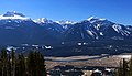
 Northwest aspect, from Griffin Lake | |
| Highest point | |
| Elevation | 2,680 m (8,793 ft) [1] |
| Prominence | 578 m (1,896 ft) [2] |
| Parent peak | Mount Tilley (2,649 m) [2] |
| Isolation | 5.15 km (3.20 mi) [2] |
| Listing | Mountains of British Columbia |
| Coordinates | 50°53′22″N 118°22′26″W / 50.88944°N 118.37389°W [3] |
| Naming | |
| Etymology | George Melville English |
| Geography | |
 Mount English Location of Mount English in British Columbia  Mount English Mount English (Canada) | |
| Location | British Columbia, Canada |
| District | Kamloops Division Yale Land District |
| Parent range |
Gold Range
[1] Monashee Mountains |
| Topo map | NTS 82L16 Revelstoke [3] |
Mount English is a 2,680-metre (8,793-foot) mountain summit located in the Gold Range of the Monashee Mountains of British Columbia, Canada. [1] Situated 17 km (11 mi) southwest of Revelstoke, this peak is visible from the Trans-Canada Highway and Revelstoke Mountain Resort ski slopes. Neighbors include Mount Macpherson 8 km (5.0 mi) to the northeast, Mount Tilley 5 km (3.1 mi) to the east, and Mount Begbie is 8 km (5.0 mi) to the east. [3] Precipitation runoff from Mount English drains into tributaries of the Eagle River. Topographic relief is significant as the summit rises 1,540 meters (5,052 ft) above Wap Creek in 3 km (1.9 mi).
Etymology
Mount English was named to remember George Melville English (1918–1943), a Canadian Army Sergeant from Revelstoke. [4] He served with the Royal Canadian Artillery, but he died September 15, 1943, age 24, in an automobile accident. [1] The mountain's toponym was officially adopted April 29, 1965, by the Geographical Names Board of Canada. [3]
Climate
Based on the Köppen climate classification, Mount English is located in a subarctic climate zone with cold, snowy winters, and mild summers. [5] Winter temperatures can drop below −20 °C with wind chill factors below −30 °C. Despite the modest elevation, the climate supports an unnamed glacier on the northeast slope.
See also
Gallery
-
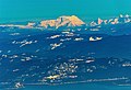 Distant view of west side of Mount English seen from Sun Peaks Resort
 -
 Left to right: Mts. Begbie, Tilley, English, Macpherson


References
- ^ a b c d Glen W. Boles, William Lowell Putnam, Roger W. Laurilla (2006), "Canadian Mountain Place Names", Rocky Mountain Books, ISBN 9781894765794, p. 89.
- ^ a b c "Mount English, Peakvisor.com". Retrieved 2023-03-09.
- ^ a b c d "Mount Englishn". Geographical Names Data Base. Natural Resources Canada. Retrieved 2023-03-09.
- ^ "Mount English". BC Geographical Names.
- ^ Peel, M. C.; Finlayson, B. L.; McMahon, T. A. (2007). "Updated world map of the Köppen−Geiger climate classification". Hydrol. Earth Syst. Sci. 11: 1633–1644. ISSN 1027-5606.
External links
- Weather forecast: Mount English