Photos • Location

| Mingchi National Forest Recreation Area Chinese: 明池國家森林遊樂區 | |
|---|---|
 | |
| Map | |
| Geography | |
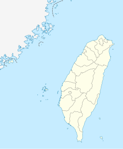
| Location | Datong, Yilan County, Taiwan |
| Coordinates | 24°39′02.4″N 121°28′23.4″E / 24.650667°N 121.473167°E |
| Elevation | 1,150-1,700 meters |
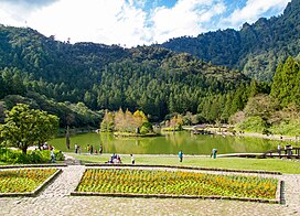
Mingchi National Forest Recreation Area ( traditional Chinese: 明池國家森林遊樂區; simplified Chinese: 明池国家森林游乐区; pinyin: Míngchí Guójiā Sēnlín Yóulè Qū) is a forest located in Datong Township, Yilan County, Taiwan. It is also named as the Pearl of the North Cross-Island Highway.
Geology
The forest is located at an altitude of 1,150-1,700 meters. [1]
Architecture
The forest features an artificial lake surrounded by gardens designed with Chinese architectural style. It also consists of Ci Garden, Fern Garden, Stone Garden, Sun Yat-sen Memorial Garden and forest trails. [1] It also consists of hostels and lookout pavilion. [2]
See also
References
- ^ a b "Mingchi Forest Recreation Area明池森林遊樂區". Yilan Tourism. 7 September 2017. Retrieved 29 August 2019.
- ^ "Mingchi Forest Recreation Area". Taiwan, the Heart of Asia. 24 August 2021. Retrieved 20 September 2022.
Wikimedia Commons has media related to
Mingchih National Forest Recreation Area.
