Photos • Location
Mahoning Furnace, Pennsylvania | |
|---|---|
Unincorporated community | |
| Coordinates: 40°56′45″N 79°21′51″W / 40.94583°N 79.36417°W | |
| Country | United States |
| State | Pennsylvania |
| County | Armstrong |
| Township | Mahoning |
| Elevation | 879 ft (268 m) |
| Time zone | UTC-5 ( Eastern (EST)) |
| • Summer ( DST) | UTC-4 (EDT) |
| GNIS feature ID | 1200799 [1] |
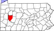
Mahoning Furnace is an unincorporated community in Mahoning Township, Armstrong County, Pennsylvania, United States. [1] [2] [3] The community is located on Pennsylvania Route 28, south-southwest of New Bethlehem near Mahoning creek.
History
Mahoning Furnace is the location where a steam, cold-blast, charcoal furnace, was erected by Alexander and John A. Colwell in the summer of 1845. [4] A post office called Mahoning Furnace was established in 1877 and remained in operation until 1886. [5]
References
- ^ a b "Mahoning Furnace". Geographic Names Information System. United States Geological Survey, United States Department of the Interior.
- ^ "MG-218, Photograph Collection". phmc.state.pa.us. Commonwealth of Pennsylvania.
- ^ "Page 1, A GUIDE TO THE OLD STONE BLAST FURNACES IN WESTERN PENNSYLVANIA". journals.psu.edu. The Pennsylvania State University.
- ^ Robert Walter Smith. "History of Armstrong County Pennsylvania, Chapter 15". Chicago : Waterman, Watkins. 1883. Retrieved November 7, 2018.
- ^ "Post Offices". Jim Forte Postal History. Retrieved November 6, 2018.

