Mücka/Mikow | |
|---|---|
 Coat of arms | |
Location of Mücka/Mikow within Görlitz district  | |
 Mücka/Mikow  Mücka/Mikow | |
| Coordinates: 51°19′N 14°42′E / 51.317°N 14.700°E | |
| Country | Germany |
| State | Saxony |
| District | Görlitz |
| Municipal assoc. | Diehsa |
| Subdivisions | 3 |
| Government | |
| • Mayor (2022–29) | Uwe Blättner [1] |
| Area | |
| • Total | 24.31 km2 (9.39 sq mi) |
| Elevation | 142 m (466 ft) |
| Population (2022-12-31)
[2] | |
| • Total | 959 |
| • Density | 39/km2 (100/sq mi) |
| Time zone | UTC+01:00 ( CET) |
| • Summer ( DST) | UTC+02:00 ( CEST) |
| Postal codes | 02906 |
| Dialling codes | 035893 |
| Vehicle registration | GR, LÖB, NOL, NY, WSW, ZI |
Mücka ( German) or Mikow ( Upper Sorbian, pronounced [ˈmʲikɔf]) is a municipality in the district of Görlitz, Saxony, Germany.
The municipality is part of the recognized Sorbian settlement area in Saxony. Upper Sorbian has an official status next to German, all villages bear names in both languages.
Four villages are in the municipality; names in German and Upper Sorbian, populations as of 2022: [3]
- Mücka/Mikow, 608 inhabitants
- Förstgen/Dołha Boršć, 228 inh.
- Förstgen-Ost/Dołha Boršć-Wuchod, 101 inh. – the village's traditional name is Oelsa/Wolšina
- Leipgen/Lipinki, 34 inh.
History and notable places
The area is within the UNESCO Biosphere Reserve Upper Lausitz Heath and Pond Landscape, [4] part of the World Network of Biosphere Reserves. [4]
The Church of Förstgen/Dołha Boršć dates from the 16th century. [5] Förstgen/Dołha Boršć was initially in the parish of Baruth/Bart. The church was damaged in the Second World War. After renovations, it officially reopened in 1955. [5]
In the time of the GDR, the areas of the present municipality were in the district/Kreis Niesky in the Bezirk Dresden. The municipality of Mücka/Mikow was created in 1994.
Mücka/Mikow train station is on the Węgliniec–Roßlau railway.
-
 Former Mehling water mill on Bautzener Straße
 -
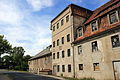
 Town hall
 -
 Church of Förstgen/Dołha Boršć


.jpg)
References
- ^ Wahlergebnisse 2022, Statistisches Landesamt des Freistaates Sachsen. Retrieved 6 July 2023.
- ^ "Einwohnerzahlen nach Gemeinden als Excel-Arbeitsmappe" (XLS) (in German). Statistisches Landesamt des Freistaates Sachsen. 2024.
- ^ Bevölkerung der Gemeinden Sachsens am 31. Dezember 2022 Statistisches Landesamt des Freistaates Sachsen
- ^ a b "Centuries-old Fish Farming; and Germany's Most Beautiful Meadow". UNESCO Germany.
- ^ a b Die Kirche in Förstgen in der Lausitz in Sachsen sachsen-lausitz.de
External links
-
 Media related to
Mücka/Mikow at Wikimedia Commons
Media related to
Mücka/Mikow at Wikimedia Commons

._Me%C3%9Ftischblatt,_1-25.000,_Sek.jpg)
| International | |
|---|---|
| National | |
|
| This Görlitz location article is a stub. You can help Wikipedia by expanding it. |