Photos • Location

Lohikoski | |
|---|---|
District of Jyväskylä | |
 An apartment building built in the 1960s and a tower block built in 2012. | |
| Coordinates: 62°15′59″N 25°45′36″E / 62.2665°N 25.7599°E | |
| Country | |
| Province | Western Finland |
| Region | Central Finland |
| Sub-region | Jyväskylä sub-region |
| City | Jyväskylä |
| Ward | Lohikoski-Seppälänkangas |
| Population (2020)
[1] | |
| • Total | 3,460 |
| Time zone | UTC+2 ( EET) |
| • Summer ( DST) | UTC+3 ( EEST) |
Lohikoski is a district of Jyväskylä, Finland and a part of the Lohikoski-Seppälänkangas ward. [2] Lahjaharju, Holsti, Kyyhkysenmäki and Paloniemi are subareas of Lohikoski. [2] The district has several services such as a school, a library and a convenience store. Also the Seppälä fire station and the Lahjaharju graveyard are located in the area. [3]
-
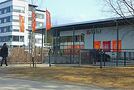 A convenience store in Lohikoski.
 -
 Single-family houses in the area.
 -
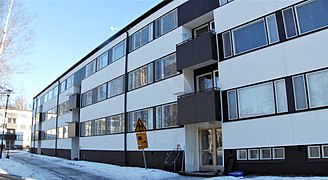 An apartment building built in the 1960s.
 -
 Lohikoski Church
 -
 A house in Holsti.
 -
 Seppälä fire station


- ^ "Jyväskylä suuralueittain". Jyväskylän kaupunki. 2021. Retrieved 2022-01-01.
- ^ a b "Jyväskylä map service". kartta.jkl.fi. Retrieved 2018-05-28.
- ^ "Jyväskylä: Asuinalueet: Lohikoski". www.jyvaskyla.fi (in Finnish). Retrieved 2018-05-28.
