Photos • Location
LogroƱoāAgoncillo Airport Aeropuerto de LogroƱo-Agoncillo | |||||||||||
|---|---|---|---|---|---|---|---|---|---|---|---|
 | |||||||||||
 | |||||||||||
| Summary | |||||||||||
| Airport type | Public | ||||||||||
| Owner/Operator | Aena | ||||||||||
| Location | LogroƱo, La Rioja, Spain | ||||||||||
| Elevation AMSL | 1,156 ft / 352 m | ||||||||||
| Coordinates | 42Ā°27ā²37ā³N 002Ā°19ā²13ā³W / 42.46028Ā°N 2.32028Ā°W | ||||||||||
| Runways | |||||||||||
| |||||||||||
| Statistics (2018) | |||||||||||
| |||||||||||
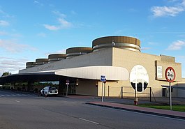
LogroƱoāAgoncillo Airport ( IATA: RJL, ICAO: LERJ) is the airport serving LogroƱo in the autonomous community of La Rioja, Spain.
History
This airport is located near Recajo village in the Agoncillo municipal term. It first opened as a military airport in 1923, when it was known as AerĆ³dromo de Recajo. It changed its name to AerĆ³dromo de Agoncillo in 1932 when it was used by the Spanish Republican Air Force. [3] In the late 1950s, the Spanish Air Force ceased most of its operations in Recajo and the aerodrome was transformed to an airport for civilian use.
Airlines and destinations
The following airlines operate regular scheduled and charter flights at LogroƱo Airport:
| Airlines | Destinations |
|---|---|
| Iberia |
Madrid Seasonal: Palma de Mallorca [4] |
Statistics
Graphs are unavailable due to technical issues. There is more info on
Phabricator and on
MediaWiki.org. |
Annual passenger traffic at RJL airport.
See
Wikidata query.
References
External links
- LogroƱoāAgoncillo Airport at Aena website (in English)
- Current weather for LELO at NOAA/ NWS