Photos • Location
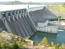
Beaver Dam impounds the
White River, creating
Beaver Lake.

Lake Ann is a private reservoir in
Bella Vista.

There are at least 20 named lakes and reservoirs in Benton County, Arkansas.
Lakes
According to the United States Geological Survey, there are no named lakes in Benton County.


Reservoirs
- Beaver Lake, 36°14′08″N 093°56′34″W / 36.23556°N 93.94278°W, el. 1,122 feet (342 m) [1]
- Bella Vista Lake, 36°26′00″N 094°13′25″W / 36.43333°N 94.22361°W, el. 1,142 feet (348 m) [2]
- Crystal Lake, 36°20′25″N 094°26′21″W / 36.34028°N 94.43917°W, el. 1,165 feet (355 m) [3]
- Guerrero Lake Number One, 36°17′53″N 094°29′53″W / 36.29806°N 94.49806°W, el. 1,220 feet (370 m) [4]
- Guerrero Lake Number Three, 36°18′30″N 094°29′14″W / 36.30833°N 94.48722°W, el. 1,191 feet (363 m) [5]
- Gurrero Lake Number Two, 36°18′07″N 094°29′40″W / 36.30194°N 94.49444°W, el. 1,188 feet (362 m) [6]
- Jackson Lake, 36°22′18″N 094°14′25″W / 36.37167°N 94.24028°W, el. 1,211 feet (369 m) [7]
- Lake Ann, 36°28′24″N 094°13′31″W / 36.47333°N 94.22528°W, el. 1,053 feet (321 m) [8]
- Lake Atalanta, 36°20′16″N 094°05′54″W / 36.33778°N 94.09833°W, el. 1,214 feet (370 m) [9]
- Lake Avalon, 36°28′24″N 094°15′43″W / 36.47333°N 94.26194°W, el. 1,066 feet (325 m) [10]
- Lake Bentonville, 36°21′07″N 094°13′10″W / 36.35194°N 94.21944°W, el. 1,276 feet (389 m) [11]
- Lake Brittany, 36°28′03″N 094°12′04″W / 36.46750°N 94.20111°W, el. 1,201 feet (366 m) [12]
- Lake Flint Creek, 36°15′05″N 094°32′03″W / 36.25139°N 94.53417°W, el. 1,135 feet (346 m) [13]
- Lake Frances, 36°07′48″N 094°33′53″W / 36.13000°N 94.56472°W, el. 906 feet (276 m) [14]
- Lake Keith, 36°15′42″N 094°14′01″W / 36.26167°N 94.23361°W, el. 1,135 feet (346 m) [15]
- Lake Norwood, 36°28′36″N 094°14′55″W / 36.47667°N 94.24861°W, el. 1,007 feet (307 m) [16]
- Lake Rayburn, 36°27′36″N 094°14′49″W / 36.46000°N 94.24694°W, el. 994 feet (303 m) [17]
- Lake Windsor, 36°28′12″N 094°15′31″W / 36.47000°N 94.25861°W, el. 1,070 feet (330 m) [18]
- Siloam Springs Lake, 36°13′29″N 094°32′19″W / 36.22472°N 94.53861°W, el. 1,043 feet (318 m) [19]
- Upper Pond, 36°21′00″N 094°17′43″W / 36.35000°N 94.29528°W, el. 1,270 feet (390 m) [20]
See also
Notes
- ^ "Beaver Lake". Geographic Names Information System. United States Geological Survey, United States Department of the Interior.
- ^ "Bella Vista Lake". Geographic Names Information System. United States Geological Survey, United States Department of the Interior.
- ^ "Crystal Lake". Geographic Names Information System. United States Geological Survey, United States Department of the Interior.
- ^ "Guerrero Lake Number One". Geographic Names Information System. United States Geological Survey, United States Department of the Interior.
- ^ "Guerrero Lake Number Three". Geographic Names Information System. United States Geological Survey, United States Department of the Interior.
- ^ "Gurrero Lake Number Two". Geographic Names Information System. United States Geological Survey, United States Department of the Interior.
- ^ "Jackson Lake". Geographic Names Information System. United States Geological Survey, United States Department of the Interior.
- ^ "Lake Ann". Geographic Names Information System. United States Geological Survey, United States Department of the Interior.
- ^ "Lake Atalanta". Geographic Names Information System. United States Geological Survey, United States Department of the Interior.
- ^ "Lake Avalon". Geographic Names Information System. United States Geological Survey, United States Department of the Interior.
- ^ "Lake Bentonville". Geographic Names Information System. United States Geological Survey, United States Department of the Interior.
- ^ "Lake Brittany". Geographic Names Information System. United States Geological Survey, United States Department of the Interior.
- ^ "Lake Flint Creek". Geographic Names Information System. United States Geological Survey, United States Department of the Interior.
- ^ "Lake Frances". Geographic Names Information System. United States Geological Survey, United States Department of the Interior.
- ^ "Lake Keith". Geographic Names Information System. United States Geological Survey, United States Department of the Interior.
- ^ "Lake Norwood". Geographic Names Information System. United States Geological Survey, United States Department of the Interior.
- ^ "Lake Rayburn". Geographic Names Information System. United States Geological Survey, United States Department of the Interior.
- ^ "Lake Windsor". Geographic Names Information System. United States Geological Survey, United States Department of the Interior.
- ^ "Siloam Springs Lake". Geographic Names Information System. United States Geological Survey, United States Department of the Interior.
- ^ "Upper Pond". Geographic Names Information System. United States Geological Survey, United States Department of the Interior.
Municipalities and communities of
Benton County, Arkansas, United States | ||
|---|---|---|
| Cities |  | |
| Towns | ||
| Townships | ||
| CDPs | ||
|
Other communities | ||
| Ghost towns | ||
| Footnotes | ‡This populated place also has portions in an adjacent county or counties Bethel Heights, a former municipality, is now a part of Springdale | |