Photos • Location

Broadway Bridge

Victoria or Traffic Bridge
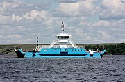
Riverhurst Ferry

Finley Bridge

This is a list of crossings of the South Saskatchewan River in the Canadian provinces of Saskatchewan and Alberta, from the river's confluence with the North Saskatchewan River at Saskatchewan River Forks, upstream to its origin at the confluence of the Bow and Oldman Rivers.


.jpg)
| Crossing | Carries | Location | Notes | Coordinates |
|---|---|---|---|---|
| Highway bridge | Highway 41 | south of Empress | 50°43′52″N 110°04′08″W / 50.731°N 110.069°W | |
| Maple Avenue Bridge [15] | Altawana Drive NE to Maple Avenue | Medicine Hat | 50°02′42″N 110°40′26″W / 50.045°N 110.674°W | |
| Railway bridge [16] | Canadian Pacific Railway | 50°02′38″N 110°40′34″W / 50.044°N 110.676°W | ||
| Finlay Bridge [17] | 2nd Avenue NE to 6th Avenue SE | 50°02′35″N 110°40′44″W / 50.043°N 110.679°W | ||
| Highway bridge [18] | Highway 1 | twin spans | 50°02′38″N 110°43′08″W / 50.044°N 110.719°W | |
| Highway bridge | Highway 879 | northwest of Bow Island | 49°54′18″N 111°28′37″W / 49.905°N 111.477°W |
The pipeline suspension bridge was erected in 1957 19 kilometres (12 mi) west of Burstall across the South Saskatchewan River. [19] [20]
The city of Medicine Hat hosted a public meeting proposing a Sanitary Sewer and Water Pipeline which is intended to cross the South Saskatchewan River. [21]
- ^ a b c d e f g Province of Saskatchewan, Ferry Information - Highways and Infrastructure -, archived from the original on 8 December 2007, retrieved 24 December 2008
- ^ Prince Albert Tourism, Prince Albert (PDF), archived from the original (PDF) on 26 July 2012, retrieved 24 December 2008
- ^ Government of Saskatchewan, Saskatchewan Road and Railway Bridges to 1950, retrieved 24 December 2008
- ^ Government of Saskatchewan (5 September 2001), NEW LOCATION FOR ST. LOUIS BRIDGE -, archived from the original on 25 November 2010, retrieved 24 December 2008
- ^ METISNET: A HANDBOOK OF METIS FACTS, FANCIES & FIGURES SECTION G ..., archived from the original on 10 July 2009, retrieved 24 December 2008
-
^
Gregg, Peter; Historic Trails Canoe Club; Ministry of Tourism, Sports and Recreation. (1989),
Canoe Trip, retrieved 24 December 2008
{{
citation}}
: CS1 maint: multiple names: authors list ( link) - ^ a b c City of Saskatoon (2006), Saskatoon 100, archived from the original on 23 December 2008, retrieved 24 December 2008
- ^ a b c d e BRIDGES OF SASKATOON The Wonder City Photo Gallery, archived from the original on 24 February 2008, retrieved 24 December 2008
- ^ City of Saskatoon, Circle Drive South Project, archived from the original on 15 November 2010, retrieved 16 July 2011
- ^ Town of Outlook, SkyTrail - Canada's Longest Pedestrian Bridge, archived from the original on 7 October 2008, retrieved 24 December 2008
- ^ Government of Saskatchewan (8 October 1998), NEW OUTLOOK BRIDGE OFFICIALLY OPENED
- ^ Saskatchewan Schools, Discover Lake Diefenbaker - The Gardiner Dam, archived from the original on 4 May 2006, retrieved 24 December 2008
- ^ Ferries and Bridges, Saskatchewan Landing, archived from the original on 11 January 2004, retrieved 24 December 2008
- ^ WDM Prairie Gamble - Family History Album - Story - Chesterfield ..., archived from the original on 22 July 2011, retrieved 24 December 2008
- ^ LANE CLOSURES FOR BRIDGE INSPECTION MAPLE AVE BRIDGE, ALLOWANCE ...
- ^ Anderton, G.T. (1883), The Glenbow Museum Archives Photographs Search Results First train across South Saskatchewan river, Medicine Hat, Alberta, Image No: NA-2622-10 and Image No: NA-2622-11, archived from the original on 9 April 2014, retrieved 24 December 2008
- ^ CITY CELEBRATES FINLAY BRIDGE 100 ANNIVERSARY (PDF), retrieved 24 December 2008[ permanent dead link]
- ^ FoundLocally.com Media Inc (1999–2008), Alberta Trans-Canada Highway Route: Highway #1 between Calgary and Medicine Hat, retrieved 24 December 2008
- ^ Southwest Regional Economic Development Authority Inc., LOCATION, retrieved 24 December 2008[ permanent dead link]
- ^ Untitled Document, retrieved 24 December 2008 Image of pipeline bridge
- ^ Medicine Hat, OPEN HOUSE SOUTH SASKATCHEWAN RIVER PIPELINE CROSSING (PDF), retrieved 24 December 2008