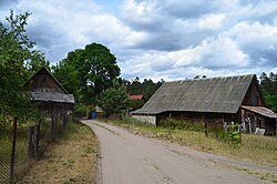
Photos • Location
Latežeris | |
|---|---|
Village | |
 | |
| Coordinates: 53°59′20″N 24°05′49″E / 53.98889°N 24.09694°E | |
| Country | |
| County |
|
| Municipality | Druskininkai |
| Population (2021) | |
| • Total | 47 [1] |
| Time zone | UTC+2 ( EET) |
| • Summer ( DST) | UTC+3 ( EEST) |
Latežeris is a village in Druskininkai municipality, in Alytus County, in south Lithuania. According to the 2011 census, the village has a population of 35 people. [2]
Latažeris village is located c. 6 kilometres (3.7 mi) from Druskininkai, 1 kilometre (0.62 mi) from Kermušija (the nearest settlement).
|
| ||||||||||||||||||||||||
| Source: 1959, 1979, 1989, 2001, 2011 2021 | |||||||||||||||||||||||||
- ^ "GYVENTOJAI GYVENAMOSIOSE VIETOVĖSE" (XLSX). Osp.stat.gov.lt. Retrieved 17 July 2022.
- ^ Gyventojai gyvenamosiose vietovėse / Population by locality, p. 430.
- "Gyventojai gyvenamosiose vietovėse / Population by locality" (PDF). Lietuvos respublikos 2011 metų gyventojų ir būstų surašymo rezultatai / Results of the 2011 Population and Housing Census of the Republic of Lithuania (in Lithuanian and English). Lietuvos statistikos departamentas / Statistics Lithuania. 2013. pp. 425–674. ISBN 978-9955-797-19-7.

