Photos • Location
Lagoa do Mato | |
|---|---|
Municipality | |
| The Municipality of Lagoa do Mato | |
| Nickname: "A Princesinha do Médio Sertão" (The Little Princess of the Middle Countryside) | |
| Motto: Lagoa do Mato seguindo em frente (Lagoa do Mato Carrying On) | |
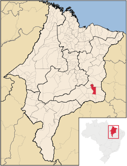
 Location of Lagoa do Mato in the
State of Maranhão | |
| Coordinates: 06°02′49″S 43°31′33″W / 6.04694°S 43.52583°W | |
| Country | Brazil |
| Region | Northeast |
| State | Maranhão |
| Founded | November 10, 1994 |
| Government | |
| • Mayor | Aluízio Coelho Duarte ( DEM) |
| Area | |
| • Total | 1,288.863 km2 (497.633 sq mi) |
| [1] | |
| Elevation | 200 m (700 ft) |
| Population (2020
[2]) | |
| • Total | 11,265 |
| • Density | 8.7/km2 (23/sq mi) |
| Time zone | UTC−3 ( BRT) |
| HDI (2000) | 0.550 – medium [3] |
| Website | www.lagoadomato.ma.gov.br |
Lagoa do Mato is a municipality in the state of Maranhão in the Northeast region of Brazil.
See also
References
-
^
IBGE -
"Archived copy". Archived from
the original on 2007-01-09. Retrieved 2007-01-09.
{{
cite web}}
: CS1 maint: archived copy as title ( link) - ^ IBGE 2020
- ^ [1] Archived 2009-10-03 at the Wayback Machine UNDP

