Labergement-Sainte-Marie | |
|---|---|
 Labergement-Sainte-Marie Town Hall | |
 Labergement-Sainte-Marie  Labergement-Sainte-Marie | |
| Coordinates: 46°46′32″N 6°16′51″E / 46.7756°N 6.2808°E | |
| Country | France |
| Region | Bourgogne-Franche-Comté |
| Department | Doubs |
| Arrondissement | Pontarlier |
| Canton | Frasne |
| Government | |
| • Mayor (2020–2026) | Ludovic Miroudot [1] |
| Area 1 | 22.12 km2 (8.54 sq mi) |
| Population (2021)
[2] | 1,241 |
| • Density | 56/km2 (150/sq mi) |
| Time zone | UTC+01:00 ( CET) |
| • Summer ( DST) | UTC+02:00 ( CEST) |
| INSEE/Postal code |
25320 /25160 |
| Elevation | 846–1,054 m (2,776–3,458 ft) |
| 1 French Land Register data, which excludes lakes, ponds, glaciers > 1 km2 (0.386 sq mi or 247 acres) and river estuaries. | |
Labergement-Sainte-Marie (French pronunciation: [labɛʁʒəmɑ̃ sɛ̃t maʁi]) is a commune in the Doubs department in the Bourgogne-Franche-Comté region in Eastern France.
Geography
The commune is situated 18 km (11 mi) south of Pontarlier between the Lac de Remoray and Lac de Saint-Point. It is dominated by the Bois de Ban and the forests of Fuvelle and Grande Côte.
-
 Labergement-Sainte-Marie in the winter
 -
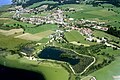 Labergement-Sainte-Marie seen from the air


History
The commune was formed from two former communes Labergement-Sainte-Marie and Granges-Sainte-Marie in 1972. Both took their names from the Cistercian abbey of Mont-Sainte-Marie.
Demographics
| Year | Pop. | ±% p.a. |
|---|---|---|
| 1968 | 541 | — |
| 1975 | 565 | +0.62% |
| 1982 | 702 | +3.15% |
| 1990 | 864 | +2.63% |
| 1999 | 920 | +0.70% |
| 2009 | 1,040 | +1.23% |
| 2014 | 1,168 | +2.35% |
| 2020 | 1,218 | +0.70% |
| Source: INSEE [3] | ||
Inhabitants are called Abergeurs (masculine) et Abergeuses (feminine) in French.
Tourism
The rich natural resources of the commune attract many visitors to the lakes and forests. There are numerous hotels, hostels, and furnished apartments available for the visitor, as well as a campground.
Transportation
The commune has a railway station, Labergement-Sainte-Marie, on the Dijon–Vallorbe line.
See also
References
- ^ "Répertoire national des élus: les maires" (in French). data.gouv.fr, Plateforme ouverte des données publiques françaises. 13 September 2022.
- ^ "Populations légales 2021" (in French). The National Institute of Statistics and Economic Studies. 28 December 2023.
- ^ Population en historique depuis 1968, INSEE
External links
| International | |
|---|---|
| National | |