Kucura
| |
|---|---|
 | |
 Kucura  Kucura  Kucura | |
| Coordinates: 45°31′N 19°35′E / 45.517°N 19.583°E | |
| Country | |
| Province | |
| Municipality | Vrbas |
| Population (2002) | |
| • Total | 4,663 |
| Time zone | UTC+1 ( CET) |
| • Summer ( DST) | UTC+2 ( CEST) |
Kucura ( Serbian Cyrillic: Куцура; Rusyn: Коцур; Hungarian: Kucora) is a village in Serbia, in the Autonomous Province of Vojvodina. It is located in the municipality of Vrbas, in the South Bačka District. The village is ethnically mixed and has a population of 4,663 (2002 census).
History
Kucura is mentioned for the first time in a Turkish defter from 1580. At that time, Kucura had 18 taxpayers, probably Hungarians. In the report of Bačka County from 1715, it is mentioned that Kucura was a small place with only 5 taxpayers. At that time, the Serbian population lived in Kucura.
In 1763, the State Chamber instructed Peter Kiš from Krstur to recruit the Ruthenian population in the northern Hungarian counties for the settlement of Kucura, which he did after signing a contract with the regional administrator of Bačka, Redl. Thus began the settlement of Rusyns in Kucura.
Kiš, according to the contract, was supposed to bring 150 Rusyns families from northern Hungary to Kucura, but he failed to do so. In 1763, 41 Rusyns families came to Kucura, and in 1767, only another 47 Rusyns families came.
The State Chamber wanted Kucura to be a purely Catholic settlement, and in 1777 they ordered the Serbs, who were almost half of the population of Kucura, to move to Obrovac. In 1792, 258 Rusyns families already lived in Kucura. [1]
Ethnic groups
1971
According to the 1971 census, ethnic Rusyns comprised 60% of the population of the village.
2002
According to the 2002 census, the population of the village include:
- 2,200 (47.18%) Rusyns
- 1,808 (38.77%) Serbs
- 352 (7.55%) Hungarians
- others.
Historical population
- 1961: 4,881
- 1971: 4,655
- 1981: 4,687
- 1991: 4,713
Boris Hodak
Gallery
-
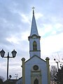
 The Uniate church.
 -
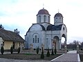 The Orthodox church.
 -
 All Saints Catholic Church.


See also
References
- ^ Gavrilović, Vladan (2012). Počeci naseljavanja Rusina u Bačku [THE BEGINNINGS OF SETTLEMENT OF RUTHENIANS IN BAČKA] (in Serbian). Novi Sad, Serbia: Filozofski fakultet Novi Sad. pp. 22–23. ISBN 978-86-6065-144-2.
- Slobodan Ćurčić, Broj stanovnika Vojvodine, Novi Sad, 1996.
External links
45°31′N 19°35′E / 45.517°N 19.583°E
| International | |
|---|---|
| National | |
|
| This South Bačka District, Vojvodina location article is a stub. You can help Wikipedia by expanding it. |