Královec | |
|---|---|
 Main road | |
 Flag  Coat of arms | |
 Královec Location in the Czech Republic | |
| Coordinates: 50°40′36″N 15°58′26″E / 50.67667°N 15.97389°E | |
| Country | |
| Region | Hradec Králové |
| District | Trutnov |
| First mentioned | 1292 |
| Area | |
| • Total | 9.94 km2 (3.84 sq mi) |
| Elevation | 512 m (1,680 ft) |
| Population (2024-01-01)
[1] | |
| • Total | 190 |
| • Density | 19/km2 (50/sq mi) |
| Time zone | UTC+1 ( CET) |
| • Summer ( DST) | UTC+2 ( CEST) |
| Postal code | 542 03 |
| Website |
www |
Královec ( German: Königshan) is a municipality and village in Trutnov District in the Hradec Králové Region of the Czech Republic. It has about 200 inhabitants.
Etymology
The German name Königshan was derived from Königshain (meaning "king's grove") and referred to a village founded on the site of a forest owned by the king. The Czech name was derived from the German name (from král = 'king'). [2]
Geography
Královec is located about 13 kilometres (8 mi) north of Trutnov and 52 km (32 mi) north of Hradec Králové. The municipality borders Poland on the north and east. It lies in the Broumov Highlands. The highest point is the hill Královecký Špičák at 881 m (2,890 ft) above sea level.
History
The first written mention of the village of Královec is from 1292, however, the woods in the area under the name Königshein were mentioned already in 1007. During its existence, the village was alternately part of the Žacléř estate, or it was owned by the town of Trutnov or by the Krzeszów Abbey. [3]
Demographics
|
|
| ||||||||||||||||||||||||||||||||||||||||||||||||||||||
| Source: Censuses [4] [5] | ||||||||||||||||||||||||||||||||||||||||||||||||||||||||
Economy

There is a quarry in the municipal territory where solid volcanic rocks are mined. [6]
Transport
The I/16 road connects the Czech-Polish border with Trutnov. On the Czech-Polish border is the railway border crossing and road border crossing Královec / Lubawka.
Královec is located on the railway line Trutnov– Sędzisław.
Sights
The main landmark of Královec is the Church of Saint John of Nepomuk. It was built in 1924–1928. [7]
The only protected cultural monuments are a statue of St. John of Nepomuk dating from 1762 and a small medieval conciliation cross. [8]
Notable people
- Mathias Czwiczek (1601–1654), painter
Gallery
-
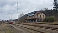 Train station
 -
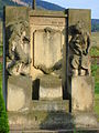 Memorial to the Fallen in the World War I
 -
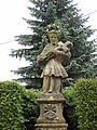 Statue of Saint John of Nepomuk


References
- ^ "Population of Municipalities – 1 January 2024". Czech Statistical Office. 2024-05-17.
- ^ Profous, Antonín (1949). Místní jména v Čechách II: CH–L (in Czech). pp. 298–299.
- ^ "Historie obce" (in Czech). Obec Královec. Retrieved 2022-10-09.
- ^ "Historický lexikon obcí České republiky 1869–2011 – Okres Trutnov" (in Czech). Czech Statistical Office. 2015-12-21. pp. 7–8.
- ^ "Population Census 2021: Population by sex". Public Database. Czech Statistical Office. 2021-03-27.
- ^ "Lom Královec" (in Czech). Geopark Broumovsko. Retrieved 2022-10-09.
- ^ "Kostel sv. Jana Nepomuckého" (in Czech). Obec Královec. Retrieved 2022-10-09.
- ^ "Výsledky vyhledávání: Kulturní památky, obec Královec". Ústřední seznam kulturních památek (in Czech). National Heritage Institute. Retrieved 2024-06-20.
External links
| Authority control databases: National |
|---|