Photos • Location

Kanjurmarg
Kanjur Gaav Kanjurmarg Village | |
|---|---|
Suburb | |

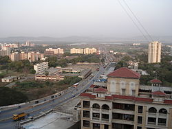
Jogeshwari - Vikhroli Link Road at Kanjur | |
| Coordinates: 19°08′N 72°56′E / 19.13°N 72.94°E | |
| Country | India |
| State | Maharashtra |
| District | Mumbai Suburban |
| City | Mumbai |
| Government | |
| • Type | Municipal Corporation |
| • Body | Brihanmumbai Municipal Corporation (MCGM) |
| Languages | |
| • Official | Marathi |
| Time zone | UTC+5:30 ( IST) |
| PIN | 400042 for East & 400078 for West |
| Area code | 022 |
| Vehicle registration | MH03 |
Kanjur Marg (Marathi pronunciation: [kaɲd͡zuɾmaːɾɡ]) is a suburb in east central Mumbai. Kanjurmarg railway station is the main access point for IIT Bombay, KV Powai, L&T, Hiranandani Gardens, and other locations in Powai. The station was built in 1968 and named after the local Kanjur village. [1]
Colleges
References
- ^ Star Track; Times of India Mumbai; pg-2; 2006-04-21
Wikimedia Commons has media related to
Kanjurmarg.

