Photos • Location

Kalijan
كاليجان | |
|---|---|
village | |
 Kalijan | |
| Coordinates: 38°38′36″N 46°29′25″E / 38.64333°N 46.49028°E | |
| Country | |
| Province | East Azerbaijan |
| County | Varzaqan |
| Bakhsh | Central |
| Rural District | Sina |
| Population (2006) | |
| • Total | 75 |
| Time zone | UTC+3:30 ( IRST) |
| • Summer ( DST) | UTC+4:30 ( IRDT) |
Kalijan ( Persian: كاليجان, also Romanized as Kalījān; also known as Kaladzha, Kāljān, Ohālja, and Ūhāljeh) [1] is a village in Sina Rural District, in the Central District of Varzaqan County, East Azerbaijan Province, Iran. At the 2006 census, its population was 75, in 15 families. [2]
-
 Around the village
 -
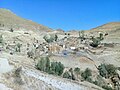 Village houses
 -
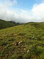 Green field around the village
 -
 Around the village


References
- ^ Kalijan can be found at GEOnet Names Server, at this link, by opening the Advanced Search box, entering "-3069165" in the "Unique Feature Id" form, and clicking on "Search Database".
- ^ "Census of the Islamic Republic of Iran, 1385 (2006)" (Excel). Statistical Center of Iran. Archived from the original on 2011-09-20.
| Capital | |||||||||||||||
|---|---|---|---|---|---|---|---|---|---|---|---|---|---|---|---|
| Districts |
| ||||||||||||||
|
| This Varzaqan County location article is a stub. You can help Wikipedia by expanding it. |