Photos • Location
Kadavoor | |
|---|---|
village | |

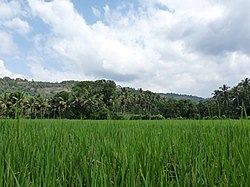
Paddy fields in Kadavoor | |
| Coordinates: 10°0′0″N 76°44′22″E / 10.00000°N 76.73944°E | |
| Country | |
| State | Kerala |
| District | Ernakulam |
| Languages | |
| • Official | Malayalam, English |
| Time zone | UTC+5:30 ( IST) |
| Telephone code | 0485 |
| Vehicle registration | KL-44 |
Kadavoor is a small village in Paingottoor Gram panchayat [1] [2] in Kothamangalam Taluk [3] at the eastern border of the Ernakulam district, state of Kerala, India. [4] It is located about twenty kilometres away from the nearby towns Muvattupuzha, Kothamangalam and Thodupuzha.
References
- ^ "Grama Panchayats". Archived from the original on 21 August 2015. Retrieved 13 July 2015.
- ^ "Panchayats_Ernakulam". Archived from the original on 8 May 2013. Retrieved 27 January 2014.
- ^ "Taluks_Ernakulam". Archived from the original on 23 May 2013. Retrieved 27 January 2014.
- ^ "Villages - Ernakulam". Archived from the original on 7 January 2014. Retrieved 7 January 2014.
External links
-
 Media related to
Kadavoor at Wikimedia Commons
