Photos • Location
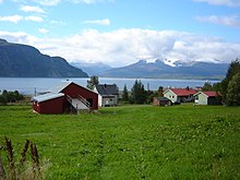
View of the fjord

| |
|---|---|
 View of the fjord | |
|
Interactive map of the fjord | |
| Location | Troms county, Norway |
| Coordinates | 69°31′03″N 20°43′45″E / 69.51746°N 20.72914°E |
| Type | Fjord |
| Basin countries | Norway |
| Max. length | 20 kilometres (12 mi) |
| Max. width | 3.5 kilometres (2.2 mi) |
| Settlements | Birtavarre, Olderdalen |
Kåfjorden ( Norwegian), Gáivuotna ( Northern Sami), or Kaivuono ( Kven) [1] is a fjord in Gáivuotna Municipality (also known as Kåfjord Municipality) in Troms county, Norway. The 20-kilometre (12 mi) long fjord is a branch off the main Lyngen fjord stretching further inland to the village of Birtavarre. The European route E06 highway runs around the entire fjord. [2]

See also
References
- ^ "Informasjon om stadnamn". Norgeskart (in Norwegian). Kartverket. Retrieved 2024-07-07.
- ^ Thorsnæs, Geir, ed. (2018-01-23). "Kåfjorden – fjord i Gáivuotna". Store norske leksikon (in Norwegian). Kunnskapsforlaget. Retrieved 2018-08-04.
|
| This article about a location in Troms is a stub. You can help Wikipedia by expanding it. |
|
| This article about a fjord in Norway is a stub. You can help Wikipedia by expanding it. |