Photos • Location

Joy, Kansas | |
|---|---|
 | |
 Joy  Joy | |
| Coordinates: 37°35′43″N 99°23′41″W / 37.59528°N 99.39472°W [1] | |
| Country | United States |
| State | Kansas |
| County | Kiowa |
| Elevation | 2,284 ft (696 m) |
| Time zone | UTC-6 ( CST) |
| • Summer ( DST) | UTC-5 (CDT) |
| Area code | 620 |
| FIPS code | 20-35675 |
| GNIS ID | 484672 [1] |
Joy is an unincorporated community in Kiowa County, Kansas, United States. [1]
Geography
Joy is located on 19th Avenue next to the railroad between Greensburg and Mullinville. [1]
Economy
Joy has one business, a tall concrete grain elevator, otherwise the former community doesn't currently have any other buildings.
Education
The community is served by Kiowa County USD 422 public school district.
References
Further reading
External links
Municipalities and communities of
Kiowa County, Kansas, United States | ||
|---|---|---|
| Cities | 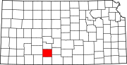 | |
|
Unincorporated communities | ||
| Township | ||