Photos • Location
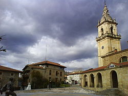
Saint Michael's church and plaza, Iurreta

Iurreta | |
|---|---|
 Partial view of Iurreta | |
|
Flag  Seal | |
| Country | Spain |
| Autonomous community | Biscay |
| Area | |
| • Total | 18.84 km2 (7.27 sq mi) |
| Elevation | 112 m (367 ft) |
| Population (2018)
[1] | |
| • Total | 3,643 |
| • Density | 190/km2 (500/sq mi) |
| Time zone | UTC+1 ( CET) |
| • Summer ( DST) | UTC+2 ( CEST) |
| Website | www.iurreta.eus |

Iurreta is a town and municipality located in the province of Biscay, in the autonomous community of Basque Autonomous Community, northern Spain. Incorporated into the municipality of Durango in 1926, Iurreta regained its independent status in 1990. The traditional anteiglesia or town meeting system of local government was revived.
External links
References
- ^ Municipal Register of Spain 2018. National Statistics Institute.

| International | |
|---|---|
| National | |
| Geographic | |
43°10′59″N 2°37′59″W / 43.18306°N 2.63306°W
|
| This article about a location in the Basque Country, Spain, is a stub. You can help Wikipedia by expanding it. |