Photos • Location

Huétor-Tájar | |
|---|---|
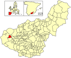
 Location of Huétor-Tájar | |
| Country | Spain |
| Province | Granada |
| Government | |
| • Mayor | Fernando Delgado Ayén ( PSOE) |
| Area | |
| • Total | 40 km2 (20 sq mi) |
| Elevation | 484 m (1,588 ft) |
| Population (2018)
[1] | |
| • Total | 10,286 |
| • Density | 260/km2 (670/sq mi) |
| Time zone | UTC+1 (CET) |
| • Summer ( DST) | UTC+2 (CEST) |
| Postal code | 18360 |
| Area code | 34 (Spain) + 958 (Granada) |
| Website | www.huetortajar.org (in Spanish) |
Huétor-Tájar (or Huétor Tájar) is a municipality and town located in the province of Granada ( Andalusia), in the southern Spain. It is situated 43 km west of the city of Granada, and its population in 2007 was 9,467. The municipality's extension is close to 40 km2. Huétor-Tájar lies within the fertile Genil river valley, a part of the Granada depression.
The main source of income is the asparagus culture and its commercialisation under the Geographical Indication Esparragos de Huétor-Tájar.
The town is located near Granada, which has had a significant influence on it during the centuries.
Notable people
- Lola Índigo (born 1992), singer and dancer
External links
- Official site for Tourism of the province of Granada
- . Encyclopædia Britannica. Vol. 12 (11th ed.). 1911. pp. 335–336.
Wikimedia Commons has media related to
Huétor Tájar.
37°11′41″N 4°02′47″W / 37.19472°N 4.04639°W
- ^ Municipal Register of Spain 2018. National Statistics Institute.

