Photos • Location


Hengevelde | |
|---|---|
 Church of Hengevelde | |
 Hengevelde Location in province of
Overijssel in the
Netherlands  Hengevelde Hengevelde (Netherlands) | |
| Coordinates: 52°12′N 6°38′E / 52.200°N 6.633°E | |
| Country | Netherlands |
| Province | Overijssel |
| Municipality | Hof van Twente |
| Area | |
| • Total | 53.98 km2 (20.84 sq mi) |
| Elevation | 15 m (49 ft) |
| Population (2021)
[1] | |
| • Total | 3,410 |
| • Density | 63/km2 (160/sq mi) |
| Time zone | UTC+1 ( CET) |
| • Summer ( DST) | UTC+2 ( CEST) |
| Postal code | 7496
[1] |
| Dialing code | 0547 |
Hengevelde (or Wegdam) is a village in the eastern Netherlands. It is located in the municipality of Hof van Twente. Until 2011 it was in Ambt Delden.
History
It was first mentioned in 1188 as Hengheuelde, and means "field on the hill". [3] It was also referred to as Wegdam. In 1806, a church was built, and the village started to develop. [4] In 1840, it was home to 355 people. [5]
Notable people
- Mike te Wierik, footballer [6]
Gallery
-
 Kulturhus de Marke
 -
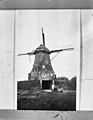 Former windmill De Bolschermolen
 -
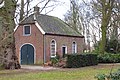 Farm in Hengeveld
 -
 Ballooning at Hengeveld (2011)


.jpg)
References
- ^ a b c "Kerncijfers wijken en buurten 2021". Central Bureau of Statistics. Retrieved 16 March 2022.
- ^ "Postcodetool for 7496AA". Actueel Hoogtebestand Nederland (in Dutch). Het Waterschapshuis. Retrieved 16 March 2022.
- ^ "Hengevelde - (geografische naam)". Etymologiebank (in Dutch). Retrieved 16 March 2022.
- ^ Ronald Stenvert & Jan ten Hove (1998). "Hengevelde" (in Dutch). Zwolle: Waanders. ISBN 90 400 9200 1. Retrieved 16 March 2022.
- ^ "Hengevelde". Plaatsengids (in Dutch). Retrieved 16 March 2022.
- ^ "Te Wierik tekent voor drie seizoenen bij Derby County". RTV Oost (in Dutch). Retrieved 16 March 2022.
Wikimedia Commons has media related to
Hengevelde.
|
| This Overijssel location article is a stub. You can help Wikipedia by expanding it. |