Photos • Location

Hawley, Kansas | |
|---|---|
| Coordinates: 38°45′42″N 98°47′56″W / 38.76167°N 98.79889°W | |
| Country | United States |
| State | Kansas |
| County | Russell |
| Elevation | 1,791 ft (546 m) |
| Time zone | UTC-6 ( Central (CST)) |
| • Summer ( DST) | UTC-5 (CDT) |
| GNIS feature ID | 481897 [1] |


Hawley was a small settlement in Fairfield Township, Russell County, Kansas, United States.
Hawley was issued a post office in 1880. The post office was discontinued in 1909. [2] The population in 1910 was 33. [3]
- ^ "US Board on Geographic Names". United States Geological Survey. 1984-07-01. Retrieved 2017-12-30.
- ^ "Kansas Post Offices, 1828-1961". Kansas Historical Society. Retrieved 2017-12-30.
- ^ Blackmar, Frank Wilson (1912). Kansas: A Cyclopedia of State History, Volume 1. Chicago: Standard Publishing Company. p. 831.
Municipalities and communities of
Russell County, Kansas, United States | ||
|---|---|---|
| Cities | 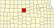 | |
|
Unincorporated communities | ||
| Ghost towns | ||
| Townships | ||
| Footnotes | ‡This community also has portions in an adjacent county or counties. | |
|
| This article about a location in Russell County, Kansas is a stub. You can help Wikipedia by expanding it. |