Photos • Location

Handy, Georgia | |
|---|---|
 Handy, Georgia | |
| Coordinates: 33°22′35″N 84°58′09″W / 33.37639°N 84.96917°W | |
| Country | United States |
| State | Georgia |
| County | Coweta |
| Elevation | 850 ft (260 m) |
| Time zone | UTC-5 ( Eastern (EST)) |
| • Summer ( DST) | UTC-4 (EDT) |
| Area code(s) | 770, 678 & 470 |
| GNIS feature ID | 331904 [1] |
Handy is an unincorporated community in Coweta County, Georgia, United States, located 9.8 miles (15.8 km) west of Newnan.
References
Municipalities and communities of
Coweta County, Georgia, United States | ||
|---|---|---|
| Cities | 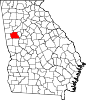 | |
| Towns | ||
| CDP | ||
|
Unincorporated communities | ||
| Footnotes | ‡This populated place also has portions in an adjacent county or counties | |
|
| This Coweta County, Georgia state location article is a stub. You can help Wikipedia by expanding it. |