| Hadhramaut Mountains | |
|---|---|
| Jibāl Ḥaḍramawt (جِبَال حَضْرَمَوْت) Jibāl Al-Mahrah (جِبَال ٱلْمَهْرَة, Mahrat Mountains) [1] | |
 Wadi Hadhramaut | |
| Highest point | |
| Coordinates | 15°18′N 50°42′E / 15.3°N 50.7°E |
| Geography | |
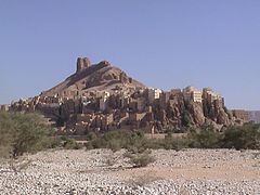
 Hadhramaut Mountains Location in Yemen  Hadhramaut Mountains Hadhramaut Mountains (Middle East)  Hadhramaut Mountains Hadhramaut Mountains (West and Central Asia) | |
| Country | |
| Region | South Arabia |
The Hadhramaut Mountains ( Arabic: جِبَال حَضْرَمَوْت, romanized: Jibāl Ḥaḍramawt), [2] also known as the "Mahrat Mountains" [1] ( Arabic: جِبَال ٱلْمَهْرَة, romanized: Jibāl Al-Mahrah), are a mountain range in Yemen. [3] They are contiguous with the Omani Dhofar Mountains to the northeast, [4] and James Canton considered Aden in the southwest to be in the mountains' recesses. [5]
Historically, the area was ruled by Qu'aiti and Kathiri sultanates. The tribal society (Hadramatis) grows wheat and millet, produces also dates, coconuts, and coffee. The area was also known for its frankincense. [6]
Geology
The south side of the mountains touches the Gulf of Aden, with steep cliffs descending onto a narrow and arid coastal plain. The northern slopes are lowering onto the Rub' al Khali desert (the "Empty Quarter"). The broad mountain plateau is intersected by deep wadis cut by seasonal streams that generally flow in the northern and northeastern direction emptying into a main channel ( Wadi Hadhramaut, changing the name to Wadi Masila downstream) [7] that makes a southeast swing of 500 miles (800 kilometres) to the ocean. [6] [8] Despite seasonality of the streams, the water is generally available year-round sub-surface in the wadis. [8]
-
 The city of Tarim
 -
 Hajjarin in Wadi Dawan
 -
 Buildings in Wadi Hadhramaut
 -
 Shibam in Wadi Hadhramaut, with mountains in the background
 -


.jpg)


See also
- Al Mahrah Governorate – partly covered by the range
- Hajhir Mountains
- Hadhramaut Governorate
- Hadhramaut Region
References
- ^ a b Cavendish, Marshall (2006). "I: Geography and climate". World and Its Peoples: The Middle East, Western Asia, and Northern Africa. Cavendish Publishing. pp. 9–144. ISBN 0-7614-7571-0.
- ^ Bilādī, ʿĀtiq ibn Ghayth (1982). بين مكة وحضرموت: رحلات ومشاهدات (in Arabic). دار مكة.
- ^ Scoville, Sheila A. (2006). Gazetteer of Arabia: a geographical and tribal history of the Arabian Peninsula. Vol. 2. Akademische Druck- u. Verlagsanstalt. pp. 117–122. ISBN 0-7614-7571-0.
- ^ Ghazanfar, Shahina A.; Fisher, Martin (2013-04-17). "1–2". Vegetation of the Arabian Peninsula. Sultan Qaboos University, Muscat, Oman: Springer Science & Business Media. pp. 27–55. ISBN 978-9-4017-3637-4.
- ^ Canton, James (2014-08-25). "4: Modernising Arabia". From Cairo to Baghdad: British Travellers in Arabia. London and New York City: I.B. Tauris. p. 91. ISBN 978-0-8577-3571-3.
- ^ a b Sattout 2020, p. 155.
- ^ Bujra & Brehony 2017, Introduction.
- ^ a b Prothero 1920, p. 6.
Bibliography
- Sattout, Eva (2020). "Hadhramaut Mountains". Geological heritage in the Arab region: Value for research and Development. UNESCO Publishing. ISBN 978-92-3-100404-9. Retrieved 2024-04-14.
- Prothero, G.W., ed. (1920). Arabia. London, H. M. Stationery office: Great Britain. Foreign Office. LCCN a22000920.
- Bujra, Abdallah; Brehony, Noel (2017). "Introduction". Hadhramaut and its Diaspora: Yemeni Politics, Identity and Migration. Bloomsbury Publishing. ISBN 978-1-78672-167-9. Retrieved 2024-04-14.
External links
Hills and
mountains on the Arabian Peninsula | |
|---|---|
Note: Mountains are sorted in alphabetical order, unless where it concerns ranges. The highest confirmed mountains in each country are indicated with 'HP', and those with the highest peak are indicated with 'HP', bearing in mind that in the UAE, the highest mountain and the mountain with the highest peak are different.
Outcrops are indicated with 'OC', and
outliers with 'OL', and
anticlines with 'AC'.
Volcanoes are indicated with 'V',
volcanic craters with 'VC',
lava fields with 'LF', and
volcanic fields with 'VF'.
Other notes:
|
.jpg)


|
| This article about a location in Yemen is a stub. You can help Wikipedia by expanding it. |