This article needs additional citations for
verification. (October 2023) |
Guyuk | |
|---|---|
LGA and town | |
| Coordinates: 9°54′20″N 11°55′42″E / 9.90556°N 11.92833°E | |
| Country |
|
| State | Adamawa State |
| Area | |
| • Total | 295.2 sq mi (764.6 km2) |
| Population (2022 estimate)
[1] | |
| • Total | 272,200 |
| • Density | 920/sq mi (360/km2) |
|
| |
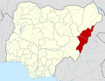
Guyuk is a town and Local Government Area in Adamawa State, Nigeria. Guyuk has many limestone deposits. [2] Guyuk is located along the Numan–Biu road.
Climate
The rainy season in Guyuk is humid and overcast, whereas the dry season is hot and partially cloudy. Throughout the year, the temperature normally ranges from 62°F to 103°F, with temperatures rarely falling below 57°F or rising over 108°F. April [3]
Average Temperature
Guyuk experiences a period of high temperatures lasting 2.4 months, starting from February 6 and ending on April 18, during which the average daily high temperature remains above 99°F. March stands out as the hottest month of the year in Guyuk, with an average high of 103°F and a low of 75°F.
On the other hand, the cooler season persists for 3.4 months, spanning from July 2 to October 13, with an average daily high temperature below 88°F. December marks the coldest month in Guyuk, characterized by an average low of 62°F and a high of 94°F. [4]
Cloud
In Guyuk, as autumn progresses, there is a notable reduction in cloud cover, with the portion of time when the sky is overcast or mostly cloudy declining from 71% to 56%.
The most unclouded day during the fall season is observed on November 26, featuring clear, mostly clear, or partly cloudy conditions approximately 44% of the time.
To provide context, on May 6, which is the cloudiest day of the year, the likelihood of overcast or mostly cloudy conditions reaches 80%, while on January 4, the clearest day of the year, there is a 57% chance of experiencing clear, mostly clear, or partly cloudy skies. [5]
Districts
- Bobini
- Banjiram
- Chikila
- Dukul
- Guyuk
- Dunma
- Bodeno
- Lokoro
- Purokayo
- Kola
Villages
- Arah
- Bodeno
- Dakiti
- Doma
- Dumburi Fulani
- Gadajuga
- Gargijik
- Gimakurje
- Gorotoro
- Jabi
- Kambila
- Katte
- Kukumli
- Labaram
- Lakati
- Libbo Dutse
- Mada
- Mittim
- Shumshi
- Vanera
- Wadafa
- Wawi
- Wurotuge
- Wuroyanka
- Zaunan-Bako [6]
References
- ^ "Ganye (Local Government Area, Nigeria) - Population Statistics, Charts, Map and Location". www.citypopulation.de. Retrieved 2024-02-05.
- ^ Samuel, TM; Maina, HM; Matera, ON (2010). "Comparative assessment of limestone resources of Guyuk and Ashaka area for Industrial utilization". J. Phys. Sci. Inno. 2: 1–8.
- ^ "Guyuk Climate, Weather By Month, Average Temperature (Nigeria) - Weather Spark". weatherspark.com. Retrieved 2023-07-12.
- ^ "Guyuk Climate, Weather By Month, Average Temperature (Nigeria) - Weather Spark". weatherspark.com. Retrieved 2023-11-02.
- ^ "Guyuk Fall Weather, Average Temperature (Nigeria) - Weather Spark". weatherspark.com. Retrieved 2023-11-02.
- ^ "Guyuk Local Government Area". www.finelib.com. Retrieved 2023-11-02.

