Photos • Location

Gura Ialomiței | |
|---|---|
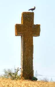 The Tall Cross, erected in honor of
Matei Basarab | |
 Location in Ialomița County | |
 Gura Ialomiței Location in Romania | |
| Coordinates: 44°42′N 27°46′E / 44.700°N 27.767°E | |
| Country | Romania |
| County | Ialomița |
| Government | |
| • Mayor (2021–2024) | Nicu Biserică [1] ( PSD) |
| Area | 43.62 km2 (16.84 sq mi) |
| Elevation | 13 m (43 ft) |
| Population (2021-12-01)
[2] | 2,258 |
| • Density | 52/km2 (130/sq mi) |
| Time zone | EET/ EEST (UTC+2/+3) |
| Postal code | 927166 |
| Area code | +(40) 243 |
| Vehicle reg. | IL |
| Website |
www |
Gura Ialomiței is a commune located in Ialomița County, Muntenia, Romania. It is composed of two villages, Gura Ialomiței and Luciu.
The Communist regime operated a forced labor camp at Luciu-Giurgeni, in between Luciu village and the nearby Giurgeni commune. [3]
References
- ^ "Results of the 2021 local elections". Central Electoral Bureau. Retrieved 30 June 2021.
- ^ "Populaţia rezidentă după grupa de vârstă, pe județe și municipii, orașe, comune, la 1 decembrie 2021" (XLS). National Institute of Statistics.
- ^ "Alexandru Teodorescu, Celula de minori. Cinci ani în temnițele și lagărele de muncă forțată ale României comuniste, Humanitas, Bucureşti, 2015, 274 p." www.iiccmer.ro (in Romanian). Institute for the Investigation of Communist Crimes in Romania. January 13, 2016. Retrieved March 3, 2024.

|
| This Ialomița County location article is a stub. You can help Wikipedia by expanding it. |