Photos • Location

You can help expand this article with text translated from
the corresponding article in Chinese. (August 2012) Click [show] for important translation instructions.
|
Guandu Bridge 關渡大橋 | |
|---|---|
 | |
| Coordinates | 25°07′32″N 121°27′26″E / 25.1256°N 121.4572°E |
| Carries |
|
| Crosses | Tamsui River |
| Locale | New Taipei, Taiwan |
| Characteristics | |
| Design | Arch bridge |
| Total length | 809 metres (2,654 ft) [1] |
| Width | 19 metres (62 ft) [1] |
| Height | 87.8 metres (288 ft) [1] |
| No. of spans | 5 |
| Piers in water | 4 |
| History | |
| Designer | Tung-Yen Lin |
| Construction start | April 1980 |
| Construction end | October 1983 |
| Opened | 31 October 1983 |
| Location | |
|
| |
25°07′32″N 121°27′26″E / 25.12556°N 121.45722°E
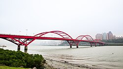
The Guandu Bridge ( Chinese: 關渡大橋; pinyin: Guāndù Dàqiáo; Pe̍h-ōe-jī: Koan To Toa Kio) is a bridge in New Taipei, Taiwan. It spans over the Tamsui River and links Bali District and Tamsui District. The bridge is a 165 meters long through arch bridge designed by Tung-Yen Lin under T.Y. Lin International. It now carries the Provincial Highway 15. [2] [3]
History
Bridge construction started in April 1980 and was completed on 31 October 1983.
Transportation
The bridge is accessible within walking distance west of Guandu Station of Taipei Metro.
See also
References
- ^ a b c "特色橋梁調查表-關渡橋". Taiwan Ministry of Transportation and Communications.
- ^ "T.Y. Lin International Group - Projects - Kuandu Bridge".
- ^ "Second phase of new Danjiang Bridge over Tamsui River begins - The China Post". Archived from the original on 2016-02-23.
Wikimedia Commons has media related to
Guandu Bridge.