From Wikipedia, the free encyclopedia
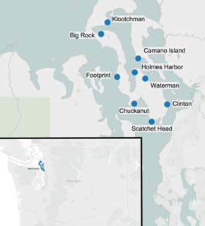
Locations of glacial erratics in Island County.
Glacial erratic boulders in Island County are a remnant of the
Pleistocene glaciation that created
Puget Sound and transformed the surfaces of what are now
Island County's main landmasses:
Whidbey Island and
Camano Island . South of
Deception Pass , the two islands' surfaces and beaches are completely composed of
glacial till .
[2] : 5 glacial erratic boulders lie on the islands, their beaches, and under the near-shore waters.
[4]
List of boulders
Big Rock Rock of Ages , is a 30-foot (9.1 m) high
greenstone erratic and a landmark on Main Street in
Coupeville , at one time considered for a city
conservation easement .
[5]
[6]
[7]
48°12′38″N 122°41′14″W / 48.21056°N 122.68722°W / 48.21056; -122.68722 (Big Rock (Coupeville) )
Camano Island State Park erratic is on the south cliff trail in
Camano Island State Park , overlooking
Saratoga Passage .
[8]
48°07′43″N 122°29′59″W / 48.12861°N 122.49972°W / 48.12861; -122.49972 (Camano Island State Park erratic )
Chuckanut erratic is a 10-foot (3.0 m) tall
Chuckanut Formation sandstone boulder on the beach below Double Bluff.
47°58′30″N 122°31′07″W / 47.97500°N 122.51861°W / 47.97500; -122.51861 (Chuckanut erratic )
The Clinton erratic is a greenstone boulder with north-south
glacial striations , at the corner of Conrad St and Berg Road above the ferry terminal in the town of
Clinton . The rock and Coupeville's Big Rock were used to calibrate
36 Clradiometric dating due to the well established date they were deposited and began to receive
cosmic ray bombardment.
[10]
[12]
47°58′23.7″N 122°21′9.36″W / 47.973250°N 122.3526000°W / 47.973250; -122.3526000 (Clinton erratic )
Footprint Rock is a boulder near Smugglers Cove on Whidbey Island's west side. The rock, high in the intertidal zone, gets its name from a "footprint like impression".
[4]
48°3′57.96″N 122°36′19.8″W / 48.0661000°N 122.605500°W / 48.0661000; -122.605500 (Footprint Rock )
The Holmes Harbor erratic is on the eastern shore of Holmes Harbor, and is somewhat taller than a man.
48°04′52″N 122°31′01″W / 48.08111°N 122.51694°W / 48.08111; -122.51694 (Holmes Harbor erratic )
Klootchman Rock (also spelled Kloochman ) is metamorphic rock boulder with white veins. The 35-foot (11 m)
[14] tall boulder topped with grass, and its broken shards sit at the base of Blowers Bluff between
Penn Cove and
Oak Harbor .
[15]
[16] The rock has a National Geodetic Survey
control station at its highest point.
[14] There is a submerged feature (bar) also called Klootchman Rock about 100 meters offshore.
[17]
48°15′00″N 122°39′14″W / 48.25000°N 122.65389°W / 48.25000; -122.65389
Scatchet Head erratics are on the beach below bluffs at the southwest point of Whidbey Island.
[18]
47°54′51.48″N 122°25′52.32″W / 47.9143000°N 122.4312000°W / 47.9143000; -122.4312000 (Scatchet Head )
Waterman Rock greenschist erratic with a circumference of 155 feet (47 m) and height of 38 feet (12 m) to 40 feet (12 m) or greater
[19]
[2] : 5 Langley .
[6]
[20]
[21] It may be the second largest erratic in Washington State, after the
Lake Stevens Monster . The property including the rock was acquired in 2002
[2] : 4
[19] for conservation.
48°03′38″N 122°27′47″W / 48.06056°N 122.46306°W / 48.06056; -122.46306 (Waterman Rock )
References
^
a b c Whidbey Camano Land Trust; Island County (August 2010),
Saratoga Management Plan (PDF) , Island County Parks ^
a b Mary Jo Adams; Judi McD. (March 7, 2008),
Intertidal Monitoring - 2007 Washington State University Island County
Extension
^
"UW professor puts Big Rock in its geologic place" , South Whidbey Record , June 25, 2008, archived from
the original on June 9, 2015 ^
a b Burnett, Justin (January 4, 2012),
"Big Rock for sale: Giant stone goes with Coupeville apartments" ,
Whidbey News-Times , retrieved June 1, 2015
^ Whalen, Nathan (January 27, 2012),
"Coupeville Town Council unmoved by Big Rock" ,
Whidbey News-Times , retrieved June 1, 2015
^ Tom Barr (July 3, 1991),
"Camano Island State Park Offers Wide Choice Of Facilities, Activities" , The Seattle Times
^ University of Washington Earth and Space Sciences 2010
^ Terry W Swanson; Marc L Caffee (January 2003), "Determination of 36 Cl Production Rates Derived from the Well-Dated Deglaciation Surfaces of Whidbey and Fidalgo Islands, Washington", Quaternary Research , 59 (1): 132–134,
doi :
10.1006/qres.2001.2278 ,
S2CID
131251443 ^
a b National Geodetic Survey PID TR1338, "Blowers Bluff Klootchman Rock"
^ Hugh Shipman (May 9, 2011),
"Klootchman Rock" , Gravel Beach (blog)
^ Overton, Harold L. (June 20, 2012),
Quadransphere of North America
^
U.S. Geological Survey Geographic Names Information System: Klootchman Rock
^ R.C. Ray (1891),
The Coast of British Columbia Including The Juan de Fuca Strait, Puget Sound, Vancouver and Queen Charlotte Islands ^
a b
"County sets Southend rockin' , South Whidbey Record , June 25, 2008, archived from
the original on February 1, 2016, retrieved June 9, 2015
^ Sheets, Bill,
"Big boulder in Edmonds one of many left by long-gone glaciers" ,
Everett Herald , archived from
the original on June 21, 2015, retrieved June 1, 2015
^ Karen Sykes (January 29, 2003),
"Hike of the week: Wandering through Whidbey Island woods" , The Seattle Times
Sources Mimi Sheridan,
"Brief history of central Whidbey Island–natural history" (PDF) , Ebey's Landing National Historic Reserve: Self-guided walking tour of historic Coupeville (brochure), U.S. National Park Service, archived from
the original (PDF) on 2015-08-12 Haugerud, Ralph (2008),
Nearshore surveys with LIDAR (PDF) , United States Geological Survey – via Washington Department of Ecology
Tucker, Dave (February 11, 2010),
"Whidbey Island erratics" , Northwest Geology Field Trips
Tucker, Dave (July 2010),
"Whidbey Island glacial deposits" , Northwest Geology Field Trips
"Whidbey Island: Glacial erratics" , Western Geo Hikes , January 29, 2008, archived from
the original on 2015-06-10
Whidbey Island Glaciation (ESS 210) (PDF) (Field trip handbook), University of Washington Department of Earth and Space Sciences Swanson, Terry W. (2009),
Late Pleistocene Glacial History of Whidbey Island, WA (PDF) (Field trip handbook), University of Washington Department of Earth and Space Sciences