Güləbird | |
|---|---|
 | |
| Coordinates: 39°28′48″N 46°36′31″E / 39.48000°N 46.60861°E | |
| Country | |
| District | Lachin |
| Population (2015)
[1] | |
| • Total | 221 |
| Time zone | UTC+4 ( AZT) |
Güləbird (Gulabird) or Tsaghkaberd ( Armenian: Ծաղկաբերդ, lit. 'castle of flowers') is a village in the Lachin District of Azerbaijan.
History
Gulabird, then called Kulaberd in Armenian ( Armenian: Կուլաբերդ), was the easternmost fortification of the Armenian Principality of Kapan (1722-1730) formed by the commander Davit Bek following the Syunik Rebellion, it is also where the modern-day village gets its name. [2]
The village was located in the Armenian-occupied territories surrounding Nagorno-Karabakh, coming under the control of ethnic Armenian forces in August 1993 during the First Nagorno-Karabakh War. The village subsequently became part of the breakaway Republic of Artsakh as part of its Kashatagh Province, referred to as Tsaghkaberd ( Armenian: Ծաղկաբերդ, lit. 'castle of flowers'). It was seized by Azerbaijan on 9 November 2020 during the Lachin offensive in the 2020 Nagorno-Karabakh war. [3]
Economy

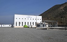
In 2021, the Gulabird hydroelectric power plant was declared reopened. [4] It is a small 8 MW power plant. [5]
Historical heritage sites
Historical heritage sites in and around the village include a cave, the 12th/13th-century rock-cut church of Kronk ( Armenian: Քրոնք), and the 17th/18th-century bridge of Kotrats ( Armenian: Կոտրած). [1]
Demographics
The village had 271 inhabitants in 2005, [6] and 221 inhabitants in 2015. [1]
See also
References
- ^ a b c Hakob Ghahramanyan. "Directory of socio-economic characteristics of NKR administrative-territorial units (2015)".
- ^ Ayvazyan 2006, p. 63.
- ^ "İşğaldan azad olunan şəhər, qəsəbə və kəndlərimiz".
- ^ HEP station opens
- ^ "Reconstruction of HPP in liberated Lachin region nearing completion". Azernews.Az. 19 January 2021. Retrieved 6 August 2022.
- ^ "The Results of the 2005 Census of the Nagorno-Karabakh Republic" (PDF). National Statistic Service of the Republic of Artsakh.
Bibliography
- Ayvazyan, Armen (2006). "1720-akan tʻvakanneri Syunyatsʻ ishkhanapetutʻyan teghagrutʻyan masin" 1720-ական թվականների Սյունյաց իշխանապետության տեղագրության մասին [About the topography of the Syunik principality of the 1720s]. Etchmiadzin (5): 60–72. ISSN 1829-4243.


