Photos • Location
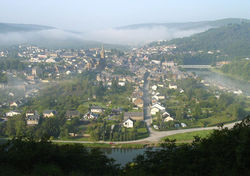
Fumay from the north-east

Fumay across the river


You can help expand this article with text translated from
the corresponding article in French. (December 2008) Click [show] for important translation instructions.
|
Fumay | |
|---|---|
 A general view of Fumay | |
 Coat of arms | |
 Fumay  Fumay | |
| Coordinates: 49°59′39″N 4°42′27″E / 49.9942°N 4.7075°E | |
| Country | France |
| Region | Grand Est |
| Department | Ardennes |
| Arrondissement | Charleville-Mézières |
| Canton | Revin |
| Intercommunality | Ardenne Rives de Meuse |
| Government | |
| • Mayor (2020–2026) | Mathieu Sonnet [1] |
| Area 1 | 37.56 km2 (14.50 sq mi) |
| Population (2021)
[2] | 3,151 |
| • Density | 84/km2 (220/sq mi) |
| Time zone | UTC+01:00 ( CET) |
| • Summer ( DST) | UTC+02:00 ( CEST) |
| INSEE/Postal code |
08185 /08170 |
| Elevation | 116–255 m (381–837 ft) (avg. 127 m or 417 ft) |
| 1 French Land Register data, which excludes lakes, ponds, glaciers > 1 km2 (0.386 sq mi or 247 acres) and river estuaries. | |
Fumay (French pronunciation: [fy.mˈɛ]) is a commune in the Ardennes department in northern France, very close to the Belgian border. The engineer Charles-Hippolyte de Paravey was born in Fumay.
Geography
It is situated in the Meuse valley, the main part of the town being surrounded by a large meander of the river.

Population
|
| ||||||||||||||||||||||||||||||||||||||||||||||||||||||||||||||||||||||||||||||||||||||||||||||||||||||||||||
| Source: EHESS [3] and INSEE (1968-2017) [4] | |||||||||||||||||||||||||||||||||||||||||||||||||||||||||||||||||||||||||||||||||||||||||||||||||||||||||||||
Economy
Fumay is sometimes known as "The City of Slate" (La Cité de l'Ardoise) due to the slate mining which brought prosperity to the town in the nineteenth century. The last slate mine was closed in 1971.

See also
References
- ^ "Répertoire national des élus: les maires" (in French). data.gouv.fr, Plateforme ouverte des données publiques françaises. 13 September 2022.
- ^ "Populations légales 2021". The National Institute of Statistics and Economic Studies. 28 December 2023.
- ^ Des villages de Cassini aux communes d'aujourd'hui: Commune data sheet Fumay, EHESS (in French).
- ^ Population en historique depuis 1968, INSEE
External links
Wikimedia Commons has media related to
Fumay.
| International | |
|---|---|
| National | |
| Geographic | |
| Other | |
|
| This Ardennes geographical article is a stub. You can help Wikipedia by expanding it. |