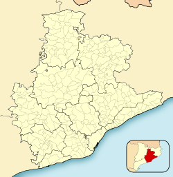
Photos • Location
Fogars de la Selva | |
|---|---|
 Sant Cebrià church, Fogars de la Selva | |
| Coordinates: 41°44′2.4″N 2°40′22.8″E / 41.734000°N 2.673000°E | |
| Country | |
| Community | |
| Province | Barcelona |
| Comarca | Selva |
| Government | |
| • Mayor | Josep Vilà Camps (2015) [1] |
| Area | |
| • Total | 32.1 km2 (12.4 sq mi) |
| Elevation | 45 m (148 ft) |
| Population (2018)
[3] | |
| • Total | 1,467 |
| • Density | 46/km2 (120/sq mi) |
| Demonym(s) | Fogarencs, fogarenques |
| Website |
fogarsdelaselva |
Fogars de la Selva is a municipality in the comarca of the Selva in Catalonia, Spain. It is situated to the north of the Montnegre range, and is linked to Tordera by a local road. The village used to be called Fogars de Tordera, and is the only municipality in the Selva to be part of the province of Barcelona rather than the province of Girona.
Demography
| 1900 | 1930 | 1950 | 1970 | 1986 | 2007 |
|---|---|---|---|---|---|
| 485 | 443 | 443 | 244 | 293 | 1437 |
References
- ^ "Ajuntament de Fogars de la Selva". Generalitat of Catalonia. Retrieved 2015-11-13.
- ^ "El municipi en xifres: Fogars de la Selva". Statistical Institute of Catalonia. Retrieved 2015-11-23.
- ^ Municipal Register of Spain 2018. National Statistics Institute.
- Panareda Clopés, Josep Maria; Rios Calvet, Jaume; Rabella Vives, Josep Maria (1989). Guia de Catalunya, Barcelona: Caixa de Catalunya. ISBN 84-87135-01-3 (Spanish). ISBN 84-87135-02-1 (Catalan).
External links
- Official website (in Catalan)
- Government data pages (in Catalan)


