
Size of this preview:
482 × 600 pixels. Other resolutions:
193 × 240 pixels |
560 × 697 pixels.
Original file (560 × 697 pixels, file size: 887 KB, MIME type: image/png)
| This is a file from the
Wikimedia Commons. Information from its
description page there is shown below. Commons is a freely licensed media file repository. You can help. |
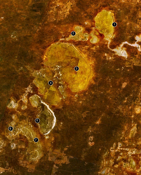
The w:Willandra Lakes Region in Australia.
- Lake Mulurulu
- Willandra Creek
- Garnpung Lake
- Lake Leaghur
- Lake Mungo
- Lake Arumpo
- Chibnalwood Lakes
| This image is in the
public domain because it is a screenshot from
NASA’s globe software
World Wind using a public domain layer, such as Blue Marble, MODIS, Landsat, SRTM, USGS or GLOBE.
|
 |
File history
Click on a date/time to view the file as it appeared at that time.
| Date/Time | Thumbnail | Dimensions | User | Comment | |
|---|---|---|---|---|---|
| current | 13:08, 28 December 2005 |
| 560 × 697 (887 KB) | Stephen Bain | The w:Willandra Lakes Region in Australia. # Lake Mulurulu # Willandra Creek # Garnpung Lake # Lake Leaghur # Lake Mungo # Lake Arumpo # Chibnalwood Lakes {{PD-WorldWind}} |
File usage
The following pages on the English Wikipedia use this file (pages on other projects are not listed):
Global file usage
The following other wikis use this file:
- Usage on ast.wikipedia.org
- Usage on be.wikipedia.org
- Usage on ca.wikipedia.org
- Usage on cs.wikipedia.org
- Usage on de.wikipedia.org
- Usage on de.wikivoyage.org
- Usage on en.wikibooks.org
- Usage on en.wikivoyage.org
- Usage on es.wikipedia.org
- Usage on fa.wikipedia.org
- Usage on fi.wikipedia.org
- Usage on fr.wikipedia.org
- Usage on he.wikipedia.org
- Usage on he.wikivoyage.org
- Usage on hr.wikipedia.org
- Usage on hu.wikipedia.org
- Usage on it.wikipedia.org
- Usage on it.wikivoyage.org
- Usage on ja.wikipedia.org
- Usage on ja.wikivoyage.org
- Usage on lt.wikipedia.org
- Usage on mt.wikipedia.org
- Usage on my.wikipedia.org
- Usage on ne.wikipedia.org
- Usage on nl.wikipedia.org
- Usage on no.wikipedia.org
- Usage on pl.wikipedia.org
- Usage on pt.wikipedia.org
- Usage on ro.wikipedia.org
- Usage on ru.wikipedia.org
- Usage on sh.wikipedia.org
- Usage on simple.wikipedia.org
- Usage on sk.wikipedia.org
- Usage on sv.wikipedia.org
- Usage on ta.wikipedia.org
- Usage on th.wikipedia.org
View more global usage of this file.