
Size of this preview:
800 × 487 pixels. Other resolutions:
320 × 195 pixels |
640 × 390 pixels |
1,024 × 624 pixels |
1,280 × 780 pixels |
3,315 × 2,020 pixels.
Original file (3,315 × 2,020 pixels, file size: 6.51 MB, MIME type: image/jpeg)
| This is a file from the
Wikimedia Commons. Information from its
description page there is shown below. Commons is a freely licensed media file repository. You can help. |
Summary
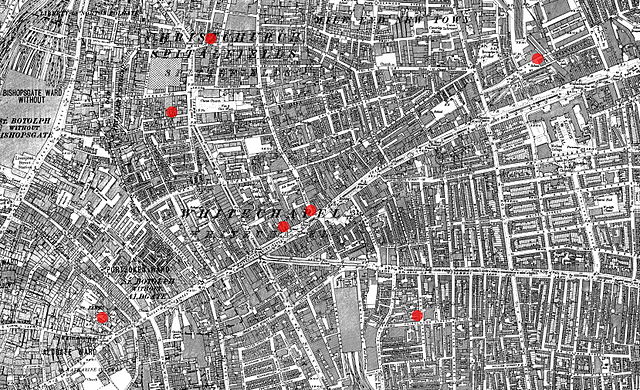
| Description | Streetmap showing the locations of the first seven en:Whitechapel murders |
| Date | 1894, modified April 2008 |
| Source |
1894 Ordnance Survey Map of Whitechapel downloaded from http://www.casebook.org/official_documents/map/images/ord_map_full.jpg Cropped and annotated with seven red dots to show the location of seven murders attributed to Jack the Ripper |
| Author | Ordnance Survey; modified by User:ΑΩ |
| Other versions | version in PNG file format : File:Whitechapel Spitalfields 7 murders.PNG |
|
|
Open this image as an overlay in Google Earth ( Google Maps, Bing) | ( Help| Source) |
Licensing
This work is an
Ordnance Survey map over 50 years old, which is covered by
Crown Copyright which in this case expires 50 years after publication. Ordnance Survey does however ask that they be credited and that the date of publication be given.
Any ancillary rights gained through the creation of the electronic version are granted as freely usable under any circumstances.
|
This work
created by the United Kingdom Government is in the
public domain.
This is because it is one of the following:
HMSO has declared that the expiry of Crown Copyrights applies worldwide (ref:
HMSO Email Reply)
|
 |
This work is based on a work in the
public domain. It has been digitally enhanced and/or modified. This derivative work has been (or is hereby) released into the
public domain by its author,
ΑΩ. This applies worldwide.
In some countries this may not be legally possible; if so: |
File history
Click on a date/time to view the file as it appeared at that time.
| Date/Time | Thumbnail | Dimensions | User | Comment | |
|---|---|---|---|---|---|
| current | 21:38, 9 November 2012 |
| 3,315 × 2,020 (6.51 MB) | DrKay | murders did not occur in that sequence |
| 21:27, 9 November 2012 |
 | 3,315 × 2,020 (7.18 MB) | Soerfm | Numbers | |
| 21:21, 3 December 2009 |
 | 3,315 × 2,020 (6.51 MB) | DrKay | Reverted to version as of 20:48, 8 April 2008: the names cannot be read easily, even at full resolution | |
| 13:23, 25 October 2009 |
 | 3,315 × 2,020 (7.34 MB) | ΛΦΠ | Added names of the victims on the map. | |
| 20:48, 8 April 2008 |
 | 3,315 × 2,020 (6.51 MB) | ΑΩ | Whitechapel / Spitalfields 7 murders |
File usage
The following pages on the English Wikipedia use this file (pages on other projects are not listed):
Global file usage
The following other wikis use this file:
- Usage on af.wikipedia.org
- Usage on ar.wikipedia.org
- Usage on ast.wikipedia.org
- Usage on bg.wikipedia.org
- Usage on cs.wikipedia.org
- Usage on da.wikipedia.org
- Usage on es.wikipedia.org
- Usage on eu.wikipedia.org
- Usage on fi.wikipedia.org
- Usage on fr.wikipedia.org
- Usage on gl.wikipedia.org
- Usage on he.wikipedia.org
- Usage on hu.wikipedia.org
- Usage on id.wikipedia.org
- Usage on ja.wikipedia.org
- Usage on kn.wikipedia.org
- Usage on ko.wikipedia.org
- Usage on la.wikipedia.org
- Usage on ne.wikipedia.org
- Usage on nn.wikipedia.org
- Usage on no.wikipedia.org
- Usage on pa.wikipedia.org
- Usage on pl.wikipedia.org
- Usage on pt.wikipedia.org
- Usage on sh.wikipedia.org
- Usage on sl.wikipedia.org
- Usage on sv.wikipedia.org
- Usage on sw.wikipedia.org
- Usage on tr.wikipedia.org
- Usage on vi.wikipedia.org
- Usage on zh-classical.wikipedia.org