
Size of this preview:
458 × 599 pixels. Other resolutions:
183 × 240 pixels |
367 × 480 pixels |
587 × 768 pixels |
783 × 1,024 pixels |
1,566 × 2,048 pixels |
5,200 × 6,800 pixels.
Original file (5,200 × 6,800 pixels, file size: 3.75 MB, MIME type: image/jpeg)
| This is a file from the
Wikimedia Commons. Information from its
description page there is shown below. Commons is a freely licensed media file repository. You can help. |
Summary
| Description |
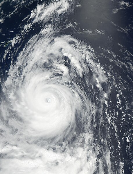
Super Typhoon Chataan reached Category 4 hurricane status on July 7 and 8, about the time this image from the Moderate Resolution Imaging Spectroradiometer (MODIS) was captured on July 8, 2002. Chataan was located in the Pacific Ocean off the south of Japan, and the outlines of Ryukyu Islands, southwest of Japan, are visible at the top left of the image. The southernmost of those islands is Okinawa. According to news reports, tens of thousands of people were asked to evacuate low-lying coastal areas as the storm skirted the east coast of the Japan, bringing high winds and heavy rains that produced floods and mudslides in the region, and disrupted transportation services. Typhoon Chataan was reportedly responsible for the deaths of at least 80 people in Micronesia, the Philippines, and Japan. Even as Chataan passed up the coast of Japan and moved northeast, another storm began brewing to the south. Now the country is bracing for the expected arrival of Typhoon Halong from the southeast and Tropical Storm Nakri from the south. |
|||||
| Date | ||||||
| Source | http://visibleearth.nasa.gov/view_rec.php?id=3675 | |||||
| Author | Jacques Descloitres, MODIS Land Rapid Response Team, NASA/GSFC | |||||
| Permission ( Reusing this file) |
|

File history
Click on a date/time to view the file as it appeared at that time.
| Date/Time | Thumbnail | Dimensions | User | Comment | |
|---|---|---|---|---|---|
| current | 16:32, 2 December 2006 |
| 5,200 × 6,800 (3.75 MB) | Good kitty | == Summary == {{Information |Description=Super Typhoon Chataan reached Category 4 hurricane status on July 7 and 8, wabout the time this image from the Moderate Resolution Imaging Spectroradiometer (MODIS) was captured on July 8, 2002. Chataan was located |
File usage
The following pages on the English Wikipedia use this file (pages on other projects are not listed):
Global file usage
The following other wikis use this file:
- Usage on es.wikipedia.org
- Usage on ko.wikipedia.org
- Usage on pl.wikipedia.org
- Usage on vi.wikipedia.org
- Usage on zh.wikipedia.org
- 2002年太平洋颱風季
- WikiProject:太平洋颱風季/條目/典範條目
- 颱風查特安
- Talk:颱風查特安
- Wikipedia:优良条目/2016年4月
- Wikipedia:优良条目/2016年4月9日
- Wikipedia:优良条目/台风查特安
- Wikipedia:典范条目/2016年5月
- Wikipedia:典范条目/2016年5月29日
- Wikipedia:典范条目/颱風查特安
- User:MCC214/2002年太平洋颱風季
- Wikipedia:典范条目/2018年9月
- Wikipedia:典范条目/2018年9月2日
- Wikipedia:典范条目/2022年5月
- Wikipedia:典范条目/2022年5月14日