
Size of this PNG preview of this SVG file:
800 × 229 pixels. Other resolutions:
320 × 92 pixels |
640 × 183 pixels |
1,024 × 293 pixels |
1,280 × 367 pixels |
2,560 × 733 pixels |
1,309 × 375 pixels.
Original file (SVG file, nominally 1,309 × 375 pixels, file size: 412 KB)
| This is a file from the
Wikimedia Commons. Information from its
description page there is shown below. Commons is a freely licensed media file repository. You can help. |
.svg)
Summary
| Description |
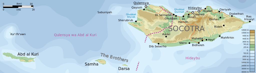
English: Topographic map of the districts of
Socotra.
Deutsch: Topographische Karte der Distrikte von
Sokotra.
Français : Carte topographique des départements de
Socotra.
Македонски: Топографска карта на
Сокотра.
Suomi:
Sokotran topografinen kartta.
Русский: Топографическая карта
Сокотры |
| Date | see file history |
| Source |
Self-made in Inkscape. |
| Author | Oona Räisänen ( Mysid) |
| Other versions |
Derivative works of this file: |
.svg)
.svg)
|
This SVG file contains embedded text that can be translated into your language, using any capable SVG editor, text editor or the SVG Translate tool. For more information see: About translating SVG files. |
.svg)
Licensing
I, the copyright holder of this work, hereby publish it under the following licenses:

|
Permission is granted to copy, distribute and/or modify this document under the terms of the GNU Free Documentation License, Version 1.2 or any later version published by the Free Software Foundation; with no Invariant Sections, no Front-Cover Texts, and no Back-Cover Texts. A copy of the license is included in the section entitled GNU Free Documentation License. |
This file is licensed under the
Creative Commons Attribution-Share Alike
Attribution-Share Alike 4.0 International,
3.0 Unported,
2.5 Generic,
2.0 Generic and
1.0 Generic license.
- You are free:
- to share – to copy, distribute and transmit the work
- to remix – to adapt the work
- Under the following conditions:
- attribution – You must give appropriate credit, provide a link to the license, and indicate if changes were made. You may do so in any reasonable manner, but not in any way that suggests the licensor endorses you or your use.
- share alike – If you remix, transform, or build upon the material, you must distribute your contributions under the same or compatible license as the original.
You may select the license of your choice.
File history
Click on a date/time to view the file as it appeared at that time.
| Date/Time | Thumbnail | Dimensions | User | Comment | |
|---|---|---|---|---|---|
| current | 20:31, 28 August 2014 |
| 1,309 × 375 (412 KB) | Chumwa | |
| 20:27, 27 August 2014 |
| 1,309 × 375 (412 KB) | Chumwa | ||
| 20:07, 27 August 2014 |
| 1,309 × 375 (413 KB) | Chumwa | == {{int:filedesc}} == {{Information |Description= {{en|Topographic map of the districts of Socotra.}} {{de|Topographische Karte der Distrikte von Sokotra.}} {{fr|Carte topographique des départements de [[:fr:Socotra|So... |
File usage
The following pages on the English Wikipedia use this file (pages on other projects are not listed):
Global file usage
The following other wikis use this file:
- Usage on ar.wikipedia.org
- Usage on arz.wikipedia.org
- Usage on bg.wikipedia.org
- Usage on bn.wikipedia.org
- Usage on ckb.wikipedia.org
- Usage on de.wikipedia.org
- Usage on es.wikipedia.org
- Usage on fa.wikipedia.org
- Usage on fr.wikipedia.org
- Usage on ja.wikipedia.org
- Usage on kk.wikipedia.org
- Usage on mt.wikipedia.org
- Usage on nn.wikipedia.org
- Usage on ru.wikipedia.org
- Usage on si.wikipedia.org
- Usage on uk.wikipedia.org
- Usage on ur.wikipedia.org
- Usage on vi.wikipedia.org
- Usage on www.wikidata.org
- Usage on zh.wikipedia.org
.svg)