
Size of this PNG preview of this SVG file:
598 × 303 pixels. Other resolutions:
320 × 162 pixels |
640 × 324 pixels |
1,024 × 519 pixels |
1,280 × 649 pixels |
2,560 × 1,297 pixels.
Original file (SVG file, nominally 598 × 303 pixels, file size: 225 KB)
| This is a file from the
Wikimedia Commons. Information from its
description page there is shown below. Commons is a freely licensed media file repository. You can help. |
Summary
| Description |
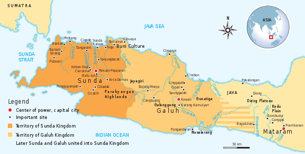
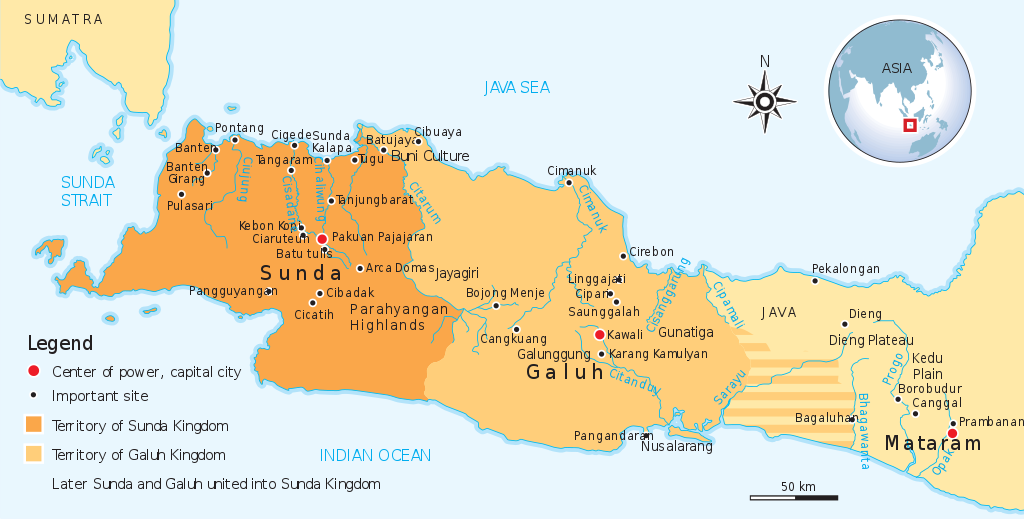
English: Historical map of the Sunda and Galuh Kingdoms of Java. |
||
| Date | |||
| Source | Own work by uploader, see #References for references used creating the map. | ||
| Author | Gunawan Kartapranata | ||
| Permission ( Reusing this file) |
I, the copyright holder of this work, hereby publish it under the following licenses: This file is licensed under the
Creative Commons
Attribution-Share Alike 3.0 Unported license.
You may select the license of your choice. |
||
| Other versions |
|


|
This SVG file contains embedded text that can be translated into your language, using any capable SVG editor, text editor or the SVG Translate tool. For more information see: About translating SVG files. |
References
Resources used to create the map:
- Munoz, Paul Michel (2006) Early Kingdoms of the Indonesian Archipelago and the Malay Peninsula, Singapore: Editions Didier Millet, pp. 203, 212 ISBN: 9814155675.
File history
Click on a date/time to view the file as it appeared at that time.
| Date/Time | Thumbnail | Dimensions | User | Comment | |
|---|---|---|---|---|---|
| current | 11:14, 8 February 2012 |
| 598 × 303 (225 KB) | Gunkarta | add Bojong Menje and Karang Kamulyan Site |
| 14:27, 8 November 2009 |
 | 604 × 306 (222 KB) | Gunkarta | ||
| 15:03, 6 November 2009 |
 | 604 × 306 (222 KB) | Gunkarta | Reverted to version as of 13:56, 6 November 2009 | |
| 14:00, 6 November 2009 |
 | 604 × 306 (222 KB) | Gunkarta | Identify separate entity of Sunda and Galuh kingdom, also remove Tarumanagara and Kalingga (Holing) because it belongs in deifferent era | |
| 13:56, 6 November 2009 |
 | 604 × 306 (222 KB) | Gunkarta | Identify the separate entity of Sunda and Galuh kingdom. Also removing Tarumanagara and Kalingga (Holing) because it is different era. | |
| 17:46, 5 November 2009 |
 | 604 × 306 (205 KB) | Gunkarta | {{Information |Description={{en|1=The historical map of Sunda Kingdom. Encompass the era from Tarumanagara, Galuh, and Sunda kingdom.}} |Source={{own}} |Author= Gunkarta Gunawan Kartapranata |Date=20091106 |Permission= |other_versions= }} |
File usage
The following pages on the English Wikipedia use this file (pages on other projects are not listed):
Global file usage
The following other wikis use this file:
- Usage on af.wikipedia.org
- Usage on ar.wikipedia.org
- Usage on az.wikipedia.org
- Usage on de.wikipedia.org
- Usage on eo.wikipedia.org
- Usage on fi.wikipedia.org
- Usage on fr.wikipedia.org
- Usage on id.wikipedia.org
- Usage on id.wikisource.org
- Usage on it.wikipedia.org
- Usage on ja.wikipedia.org
- Usage on lt.wikipedia.org
- Usage on ml.wikipedia.org
- Usage on nl.wikipedia.org
- Usage on no.wikipedia.org
- Usage on ru.wikipedia.org
- Usage on su.wikipedia.org
- Usage on sv.wikipedia.org
- Usage on uk.wikipedia.org
- Usage on www.wikidata.org
- Usage on zh.wikipedia.org