
Size of this preview:
705 × 599 pixels. Other resolutions:
282 × 240 pixels |
565 × 480 pixels |
904 × 768 pixels |
1,205 × 1,024 pixels |
2,409 × 2,048 pixels |
5,000 × 4,250 pixels.
Original file (5,000 × 4,250 pixels, file size: 6.61 MB, MIME type: image/jpeg)
| This is a file from the
Wikimedia Commons. Information from its
description page there is shown below. Commons is a freely licensed media file repository. You can help. |
| Warning | The original file is very high-resolution. It might not load properly or could cause your browser to freeze when opened at full size. |
|---|
|
|
|||||||||||||||||||||||||||||||||||||||||||||||||||||||||||||||||||||||||||||||||||||||||||||||||||||||
|---|---|---|---|---|---|---|---|---|---|---|---|---|---|---|---|---|---|---|---|---|---|---|---|---|---|---|---|---|---|---|---|---|---|---|---|---|---|---|---|---|---|---|---|---|---|---|---|---|---|---|---|---|---|---|---|---|---|---|---|---|---|---|---|---|---|---|---|---|---|---|---|---|---|---|---|---|---|---|---|---|---|---|---|---|---|---|---|---|---|---|---|---|---|---|---|---|---|---|---|---|---|---|---|
| Author |
|
||||||||||||||||||||||||||||||||||||||||||||||||||||||||||||||||||||||||||||||||||||||||||||||||||||||
| Description |
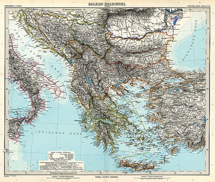
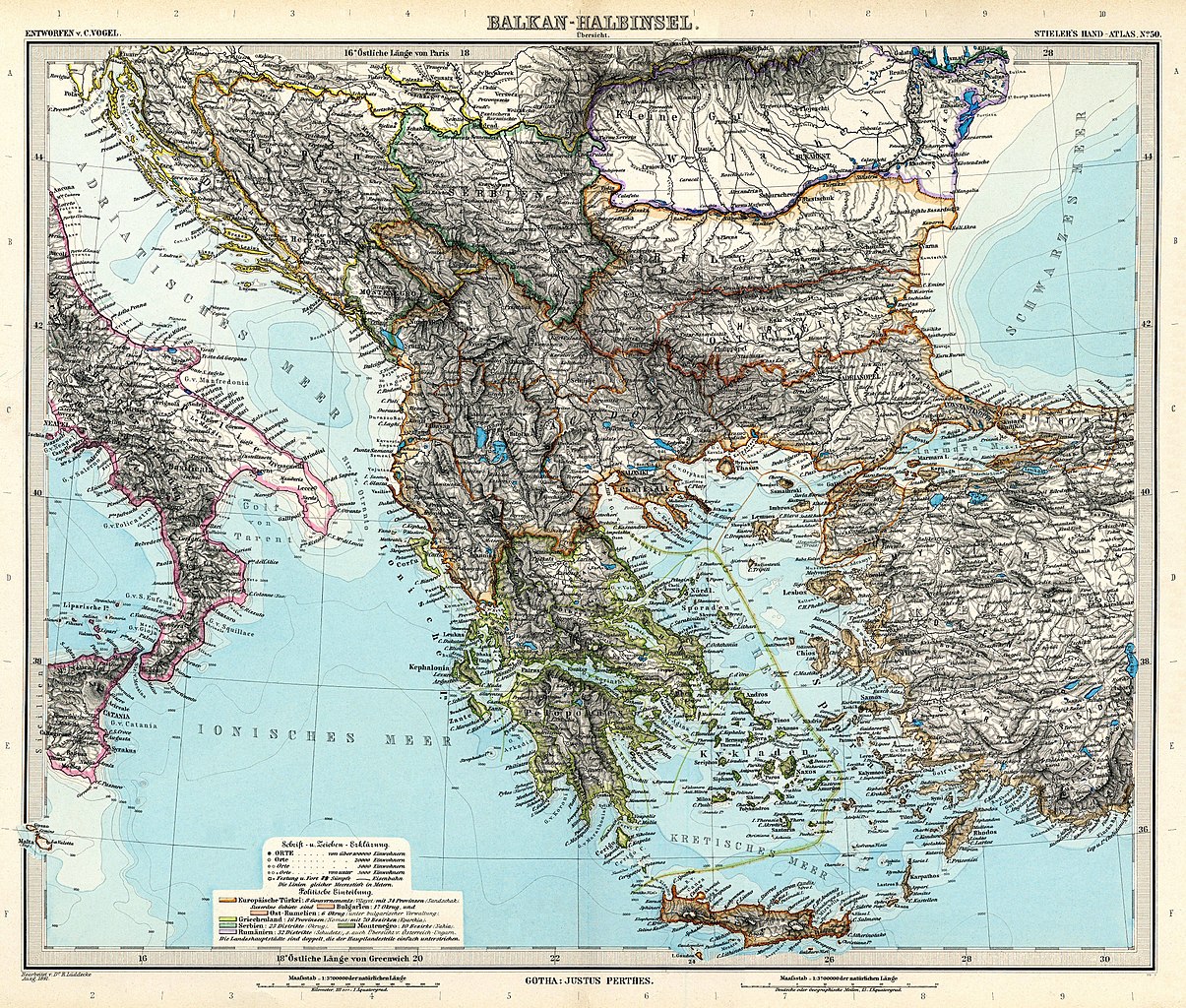
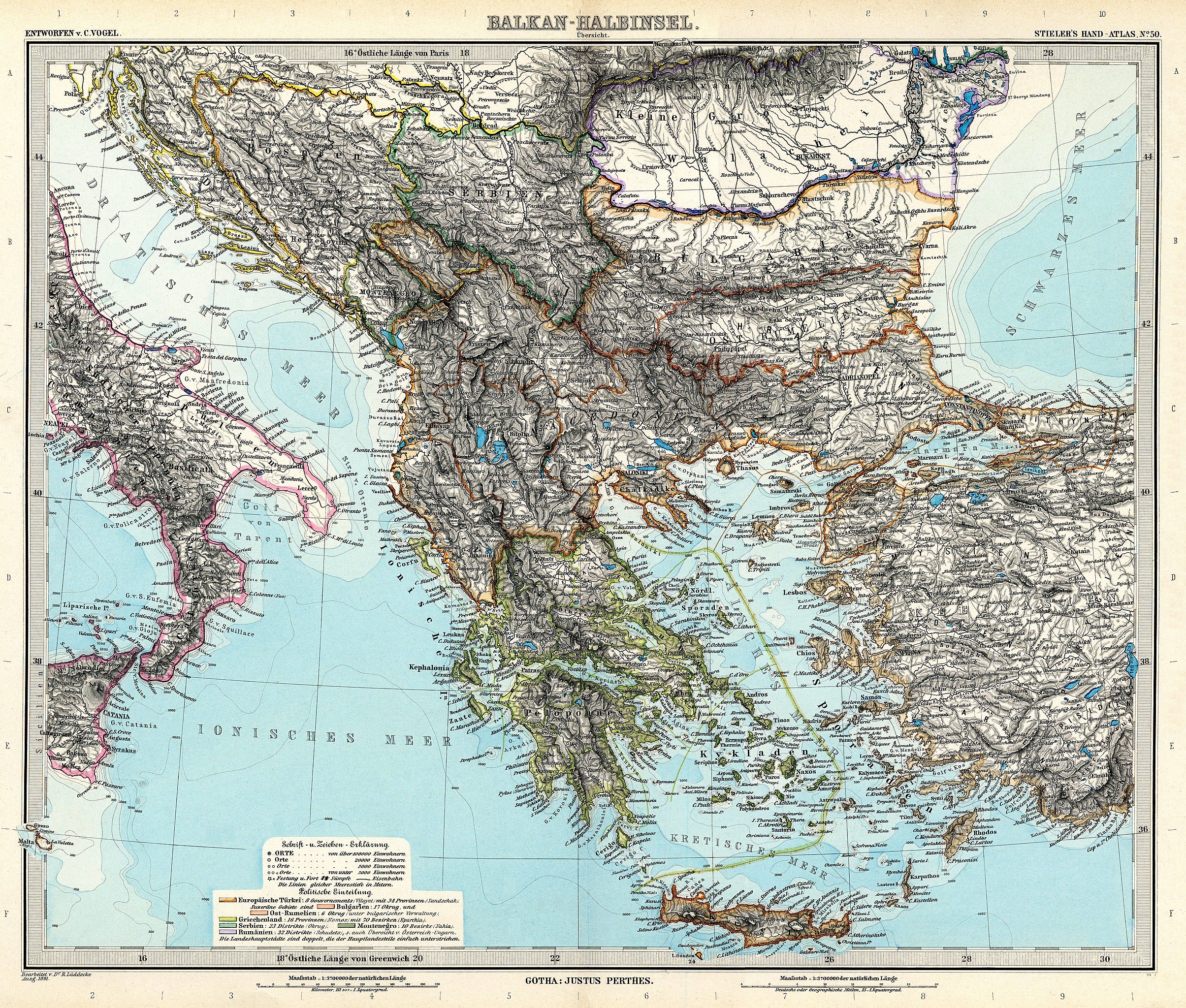
Deutsch: Balkan-Halbinsel. Übersicht
English: Balkan peninsula. Overview |
||||||||||||||||||||||||||||||||||||||||||||||||||||||||||||||||||||||||||||||||||||||||||||||||||||||
| Publication date | 1891 | ||||||||||||||||||||||||||||||||||||||||||||||||||||||||||||||||||||||||||||||||||||||||||||||||||||||
| Source | Adolf Stielers Handatlas | ||||||||||||||||||||||||||||||||||||||||||||||||||||||||||||||||||||||||||||||||||||||||||||||||||||||
| Permission ( Reusing this file) |
|
||||||||||||||||||||||||||||||||||||||||||||||||||||||||||||||||||||||||||||||||||||||||||||||||||||||


.jpg)

File history
Click on a date/time to view the file as it appeared at that time.
| Date/Time | Thumbnail | Dimensions | User | Comment | |
|---|---|---|---|---|---|
| current | 07:51, 13 March 2010 |
| 5,000 × 4,250 (6.61 MB) | Kolossos | better quality |
| 17:40, 21 November 2006 |
 | 3,749 × 3,187 (1.22 MB) | Poccil | {{Stielers Handatlas 1891|49|51|Balkan-Halbinsel. Übersicht|Balkan peninsula. Overview}} Category:Old maps of the Balkans |
File usage
The following pages on the English Wikipedia use this file (pages on other projects are not listed):
- Agricultural University of Plovdiv
- American University in Bulgaria
- Aristotle University of Thessaloniki
- Atatürk University
- Babeș-Bolyai University
- Baden-Wuerttemberg Cooperative State University Loerrach
- Baku State University
- Balkan Universities Network
- Comrat State University
- Democritus University of Thrace
- Dokuz Eylül University
- Epoka University
- Eqrem Çabej University of Gjirokastër
- European University of Lefke
- FON University
- Fan S. Noli University of Korçë
- Fırat University
- Galatasaray University
- History of the Balkans
- Iliria College
- International Balkan University
- Istanbul University
- Kırklareli University
- Luigj Gurakuqi University of Shkodër
- Mediterranean University
- Shumen University
- Sofia University
- South East European University
- Ss. Cyril and Methodius University of Skopje
- St. Clement of Ohrid University of Bitola
- State University of Tetova
- Süleyman Demirel University
- Technical University of Gabrovo
- Technical University of Varna
- Tekirdağ Namık Kemal University
- Trakya University
- University of Arts in Belgrade
- University of Belgrade
- University of Graz
- University of Ioannina
- University of Kragujevac
- University of Library Studies and Information Technologies
- University of Macedonia
- University of Medicine, Tirana
- University of Montenegro
- University of Mostar
- University of National and World Economy
- University of Novi Sad
- University of Priština (North Mitrovica)
- University of Sarajevo
- University of Thessaly
- University of Tirana
- University of Tuzla
- University of Zadar
- University of Zagreb
- University of Zenica
- Varna Free University
- Veliko Tarnovo University
- Vitrina University
- Yozgat Bozok University
- Çanakkale Onsekiz Mart University
- User:Falcaorib/Balkans
- User:Falcaorib/Balkans maps
- User:Falcaorib/Bulgaria and North Macedonia
- User:Falcaorib/Serbia, Yugoslavia and Albania
- Template:Balkan Universities Network
Global file usage
The following other wikis use this file:
- Usage on ar.wikipedia.org
- Usage on az.wikipedia.org
- Usage on ba.wikipedia.org
- Usage on ca.wikipedia.org
- Usage on cs.wikipedia.org
- Usage on da.wikipedia.org
- Usage on de.wikipedia.org
- Usage on eo.wikipedia.org
- Usage on es.wikipedia.org
- Usage on eu.wikipedia.org
- Usage on ga.wikipedia.org
- Usage on hr.wikipedia.org
- Usage on mk.wikipedia.org
- Usage on nl.wikipedia.org
- Usage on nn.wikipedia.org
- Usage on ro.wikipedia.org
- Usage on ru.wikipedia.org
- Usage on sh.wikipedia.org
- Usage on sl.wikipedia.org
- Usage on sq.wikipedia.org
- Usage on sr.wikipedia.org
- Usage on tg.wikipedia.org
- Usage on tr.wikipedia.org
- Usage on uk.wikipedia.org
- Usage on xmf.wikipedia.org
- Usage on zh.wikipedia.org