
Size of this preview:
627 × 600 pixels. Other resolutions:
251 × 240 pixels |
502 × 480 pixels |
803 × 768 pixels |
1,255 × 1,200 pixels.
Original file (1,255 × 1,200 pixels, file size: 2.7 MB, MIME type: image/png)
| This is a file from the
Wikimedia Commons. Information from its
description page there is shown below. Commons is a freely licensed media file repository. You can help. |
Summary
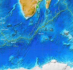
| Description | Map of the Southwest Indian Ridge. White dots–hotspots; yellow dashed lines–major fracture zones. Incomplete work in progress (bbl). |
| Date | |
| Source |
NOAA ETOPO1, additions from Georgen et al. 2001, Fig. 1 made in Inkscape.
|
| Author | NOAA, additions by Fama Clamosa ( talk) 09:04, 31 July 2016 (UTC) |
| Permission ( Reusing this file) |
PD-USGov |
Licensing
This image is in the
public domain because it contains materials that originally came from the U.S.
National Oceanic and Atmospheric Administration, taken or made as part of an employee's official duties.
|
File history
Click on a date/time to view the file as it appeared at that time.
| Date/Time | Thumbnail | Dimensions | User | Comment | |
|---|---|---|---|---|---|
| current | 09:56, 31 July 2016 |
| 1,255 × 1,200 (2.7 MB) | Fama Clamosa | Reverted to version as of 09:51, 31 July 2016 (UTC) |
| 09:53, 31 July 2016 |
 | 1,255 × 1,200 (2.7 MB) | Fama Clamosa | try again | |
| 09:51, 31 July 2016 |
 | 1,255 × 1,200 (2.7 MB) | Fama Clamosa | Labels corrected and added. | |
| 09:04, 31 July 2016 |
 | 1,255 × 1,200 (2.69 MB) | Fama Clamosa | {{Information |Description=Map of the Southwest Indian Ridge. White dots–hotspots; yellow dashed lines–major fracture zones. Incomplete work in progress (bbl). |Source=[http://maps.ngdc.noaa.gov/viewers/wcs-client/ NOAA ETOPO1], additions made in I... |
File usage
The following pages on the English Wikipedia use this file (pages on other projects are not listed):
Global file usage
The following other wikis use this file:
- Usage on ca.wikipedia.org
- Usage on de.wikipedia.org
- Usage on es.wikipedia.org
- Usage on he.wikipedia.org
- Usage on hr.wikipedia.org
- Usage on it.wikipedia.org
- Usage on ja.wikipedia.org
- Usage on pl.wikipedia.org
- Usage on ru.wikipedia.org
- Usage on sr.wikipedia.org
- Usage on sw.wikipedia.org
- Usage on zh-yue.wikipedia.org