
Size of this PNG preview of this SVG file:
800 × 556 pixels. Other resolutions:
320 × 222 pixels |
640 × 445 pixels |
1,024 × 712 pixels |
1,280 × 889 pixels |
2,560 × 1,779 pixels |
1,298 × 902 pixels.
Original file (SVG file, nominally 1,298 × 902 pixels, file size: 2.29 MB)
| This is a file from the
Wikimedia Commons. Information from its
description page there is shown below. Commons is a freely licensed media file repository. You can help. |
| Description |
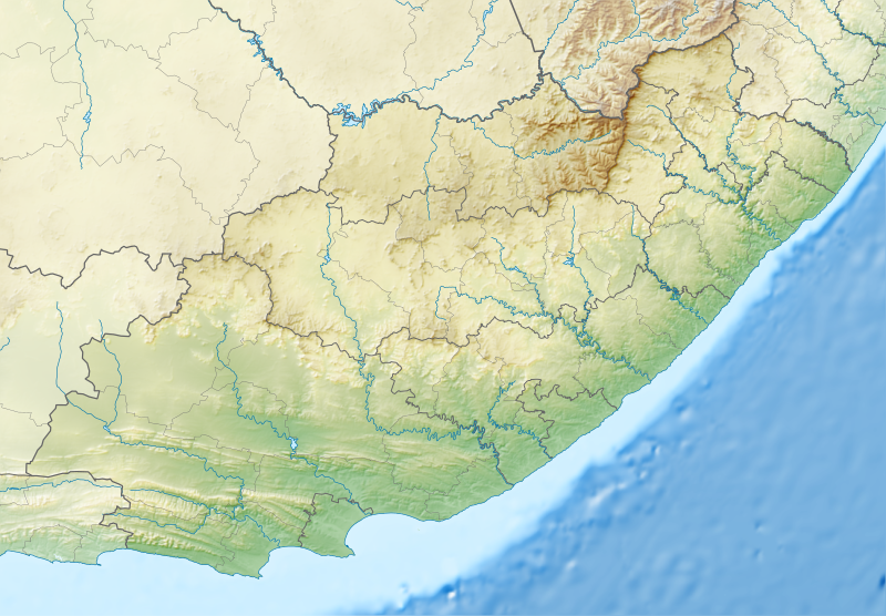
English: Relief location map of the
Eastern Cape
Equirectangular projection, N/S stretching 117%. Geographic limits of the map:
|
| Date | |
| Source |
|
| Author | Htonl |
| Permission ( Reusing this file) |
I, the copyright holder of this work, hereby publish it under the following license: This file is licensed under the
Creative Commons
Attribution-Share Alike 3.0 Unported license.
|
| Other versions | File:South Africa Eastern Cape location map.svg |
File history
Click on a date/time to view the file as it appeared at that time.
| Date/Time | Thumbnail | Dimensions | User | Comment | |
|---|---|---|---|---|---|
| current | 22:05, 4 January 2013 |
| 1,298 × 902 (2.29 MB) | Htonl | Fix Lesotho masking |
| 21:48, 4 January 2013 |
 | 1,298 × 902 (2.29 MB) | Htonl | {{Information |Description ={{en|1=Relief location map of the Eastern Cape Equirectangular projection, N/S stretching 117%. Geographic limits of the map: * N: 29.75° S * S: 34.5° S * W: 22.5° E * E: 30.5° E}} |Source ... |
File usage
The following pages on the English Wikipedia use this file (pages on other projects are not listed):
- Africa Open
- Baviaanskloof Mega Reserve
- Ben Macdhui (Eastern Cape)
- Blaauwkrantz Nature Reserve
- Blaauwkrantz Pass
- Bloukrans River (Grahamstown)
- Buffalo Kloof Protected Environment
- Chief Dawid Stuurman International Airport
- Commando Drift Nature Reserve
- Doddington (East Indiaman)
- Doringnek
- Double Mouth Nature Reserve
- East London Coast Nature Reserve
- Entle Protected Environment
- Formosa Peak
- Fort Frederick, Eastern Cape
- General Motors Open
- Great Fish River Nature Reserve
- Hluleka Nature Reserve
- Hole-in-the-Wall (Eastern Cape)
- Indalo Protected Environment
- Inkwenkwezi Private Game Reserve
- Kat River
- King Phalo Airport
- King William's Town Nature Reserve
- Kouga Dam
- Kragga Kamma Game Park
- Kwelera National Botanical Garden
- Kwelera Nature Reserve
- MTS Oceanos
- Makana Botanical Gardens
- Melkhoutboom Cave
- Mountain Zebra National Park
- Mpofu Nature Reserve
- Mthatha
- Mthatha Airport
- Nahoon Nature Reserve
- Nahoon River
- Nelson Mandela Bay Championship
- Nqweba Dam
- Olifantskop Pass
- Orange–Fish River Tunnel
- Oviston Nature Reserve
- Plettenberg Bay Aerodrome
- Port Alfred Airport
- Quenera Nature Reserve
- SDC Championship
- Shamwari Game Reserve
- Silaka Nature Reserve
- South African Masters
- South African PGA Championship
- St. Croix Island (Algoa Bay)
- Suurberg
- Suurberg Pass
- Thomas Baines Nature Reserve
- Tsolwana Nature Reserve
- Venpet–Venoil collision
- Waters Meeting Nature Reserve
- User:Xhantar/Sandbox2
- Module:Location map/data/Eastern Cape
- Module:Location map/data/South Africa Eastern Cape
- Module:Location map/data/South Africa Eastern Cape/doc
Global file usage
The following other wikis use this file:
- Usage on af.wikipedia.org
- Usage on ar.wikipedia.org
- Usage on ban.wikipedia.org
- Usage on bg.wikipedia.org
- Usage on bn.wikipedia.org
- Usage on ceb.wikipedia.org
- Usage on de.wikipedia.org
- Usage on eo.wikipedia.org
- Usage on es.wikipedia.org
- Usage on fa.wikipedia.org
- Usage on frr.wikipedia.org
- Usage on fr.wikipedia.org
- Usage on fy.wikipedia.org
- Usage on he.wikipedia.org
View more global usage of this file.