
Size of this PNG preview of this SVG file:
512 × 406 pixels. Other resolutions:
303 × 240 pixels |
605 × 480 pixels |
969 × 768 pixels |
1,280 × 1,015 pixels |
2,560 × 2,030 pixels.
Original file (SVG file, nominally 512 × 406 pixels, file size: 1.78 MB)
| This is a file from the
Wikimedia Commons. Information from its
description page there is shown below. Commons is a freely licensed media file repository. You can help. |
Summary
| Description |
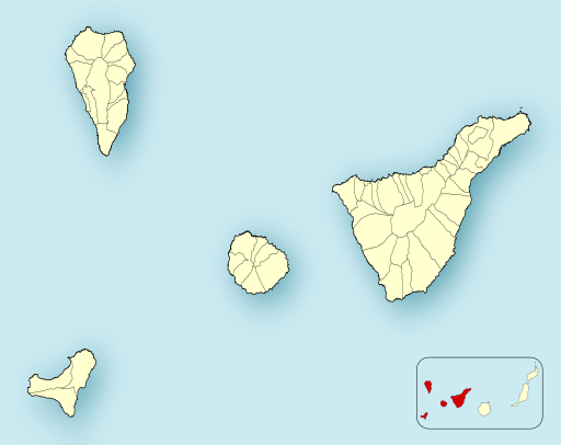
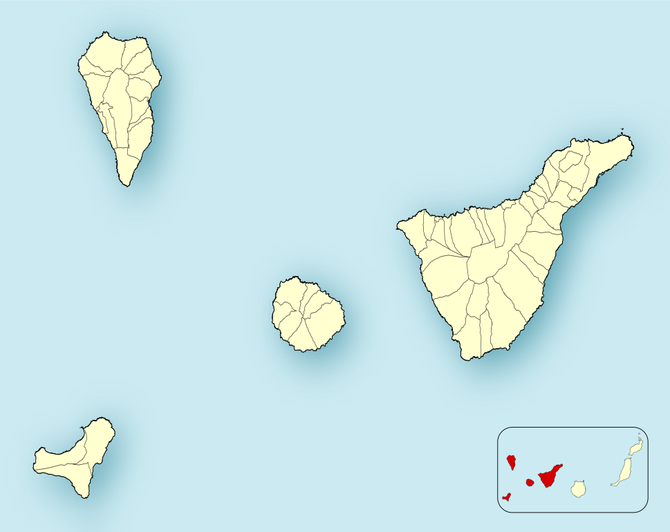
English: Location map of
Province of Santa Cruz de Tenerife
Equirectangular projection, N/S stretching 130 %. Geographic limits of the map:
Español: Mapa de localización de las
Provincia de Santa Cruz de Tenerife
Proyección equirrectangular (cilíndrica equidistante), N/S estirada 130 %. Límites geográficos del mapa:
|
|
| Date | ||
| Source | Own work based on: EspañaLoc.svg by HansenBCN | |
| Author | Miguillen | |
| SVG development | This
locator map was created with
Inkscape.
|
Licensing
Miguillen, the copyright holder of this work, hereby publishes it under the following license:
This file is licensed under the
Creative Commons
Attribution-Share Alike 3.0 Unported license.
Attribution:
Miguillen
- You are free:
- to share – to copy, distribute and transmit the work
- to remix – to adapt the work
- Under the following conditions:
- attribution – You must give appropriate credit, provide a link to the license, and indicate if changes were made. You may do so in any reasonable manner, but not in any way that suggests the licensor endorses you or your use.
- share alike – If you remix, transform, or build upon the material, you must distribute your contributions under the same or compatible license as the original.
File history
Click on a date/time to view the file as it appeared at that time.
| Date/Time | Thumbnail | Dimensions | User | Comment | |
|---|---|---|---|---|---|
| current | 18:25, 2 June 2012 |
| 512 × 406 (1.78 MB) | Miguillen | borde |
| 18:15, 2 June 2012 |
 | 512 × 406 (1.77 MB) | Miguillen | ||
| 17:11, 2 June 2012 |
 | 512 × 409 (57 KB) | Miguillen | ||
| 15:50, 2 June 2012 |
 | 512 × 406 (1.77 MB) | Miguillen | actualizo mapa | |
| 16:12, 10 December 2010 |
 | 512 × 409 (57 KB) | Miguillen | mosca con la CCAA según convención | |
| 15:27, 21 November 2010 |
 | 512 × 409 (98 KB) | Miguillen | elimino nodos imnecesarios en medio dela isla de Tenerife | |
| 15:11, 21 November 2010 |
 | 512 × 409 (98 KB) | Miguillen | estiro un 130 % | |
| 18:05, 18 November 2010 |
 | 512 × 315 (43 KB) | Miguillen | == {{int:filedesc}} == {{Information |Description={{en|Location map of Province of Santa Cruz de Tenerife}} Equirectangular projection, N/S stretching 130 %. Geographic limits of the map: * N: ° N * S: ° N |
File usage
The following pages on the English Wikipedia use this file (pages on other projects are not listed):
- 2011–12 El Hierro eruption
- 2024–25 Tercera Federación
- El Sauzal
- El Tanque
- Fasnia
- La Victoria de Acentejo
- Los Silos
- MS Benchi Express
- San Miguel de Abona
- Santa Úrsula
- Santiago del Teide
- Segunda División B de Futsal
- Tacoronte
- Tagoro
- Tegueste
- Vilaflor, Santa Cruz de Tenerife
- Module:Location map/data/Spain Province of Santa Cruz de Tenerife
- Module:Location map/data/Spain Province of Santa Cruz de Tenerife/doc
Global file usage
The following other wikis use this file:
- Usage on ar.wikipedia.org
- كانديلاريا (سانتا كروث دي تينيريفه)
- لوس يانوس دي أريداني
- أديخي
- أغولو
- ألاخيرو
- أرافو
- أرونا (إسبانيا)
- لا أوروتافا
- غراناديا دي أبونا
- لوس رياليخوس
- إكود دي لوس فينوس
- تاكورونتي
- غيا دي إسورا
- غويمار
- إل روساريو (سانتا كروث دي تينيريفه)
- سانتا كروث دي لا بالما
- سان ميغيل دي أبونا
- سانتا أورسولا
- سانتياغو ديل تيدي
- تيغيستي
- سان سيباستيان دي لا غوميرا
- لا فيكتوريا دي أثينتيخو
- إل ساوثال
- لا متانثا دي أثينتيخو
- أريكو
- إل باسو (سانتا كروث دي تينيريفه)
- برينيا ألتا
- تاثاكورتي
- لا غوانتشا
- غاراتشيكو
- برينيا باخا
- لوس سيلوس
- بوينافيستا ديل نورتي
- فايي غران ري
- سان خوان دي لا رامبلا
- فالفيردي (سانتا كروث دي تينيريفه)
- فيا دي ماثو
- سان أندريس إي ساوثيس
- لا فرونتيرا (سانتا كروث دي تينيريفه)
- فايرموسو (سانتا كروث دي تينيريفه)
- إل تانكي
- فاسنيا
- تيخارافي
- بونتايانا
- بارلوفينتو (سانتا كروث دي تينيريفه)
- إرميغوا
- بونتاغوردا
- فوينكالينتي دي لا بالما
- فيلافلور (سانتا كروث دي تينيريفه)
- إل بينار دي إل هييرو
View more global usage of this file.