
Size of this preview:
800 × 505 pixels. Other resolutions:
320 × 202 pixels |
640 × 404 pixels |
1,024 × 646 pixels |
1,280 × 808 pixels |
2,560 × 1,616 pixels |
3,963 × 2,502 pixels.
Original file (3,963 × 2,502 pixels, file size: 5.2 MB, MIME type: image/jpeg)
| This is a file from the
Wikimedia Commons. Information from its
description page there is shown below. Commons is a freely licensed media file repository. You can help. |
Summary
| Description |
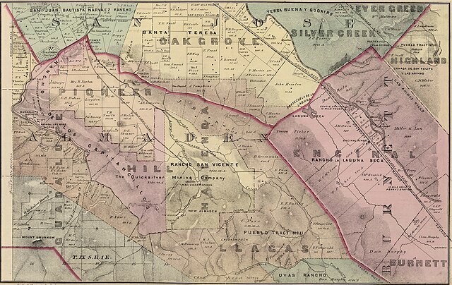
English: Hand col. lithographed map. Relief shown by hachures. Shows townships the like Burnett Township, Public Land Survey System townships, sections, quarter sections, etc., land grants, owners of large parcels with acreage, roads, railroads, schools, mines, etc. |
| Date | |
| Source | Rumsey Collection |
| Author | Thompson & West |
Licensing
This work is in the
public domain in the
United States because it was
published (or registered with the
U.S. Copyright Office) before January 1, 1929.
Public domain works must be out of copyright in both the United States and in the source country of the work in order to be hosted on the Commons. If the work is not a U.S. work, the file must have an additional
copyright tag indicating the copyright status in the source country.
Note: This tag should not be used for sound recordings. |
File history
Click on a date/time to view the file as it appeared at that time.
| Date/Time | Thumbnail | Dimensions | User | Comment | |
|---|---|---|---|---|---|
| current | 04:51, 25 June 2024 |
| 3,963 × 2,502 (5.2 MB) | Greghenderson2006 | Uploaded a work by Thompson & West from [https://www.davidrumsey.com/luna/servlet/detail/RUMSEY~8~1~21682~660045:Santa-Clara-Co--8- Rumsey Collection] with UploadWizard |
File usage
The following pages on the English Wikipedia use this file (pages on other projects are not listed):