
Size of this preview:
450 × 600 pixels. Other resolutions:
180 × 240 pixels |
360 × 480 pixels |
576 × 768 pixels |
768 × 1,024 pixels |
1,500 × 2,000 pixels.
Original file (1,500 × 2,000 pixels, file size: 4.02 MB, MIME type: image/png)
| This is a file from the
Wikimedia Commons. Information from its
description page there is shown below. Commons is a freely licensed media file repository. You can help. |
Summary
| Description |
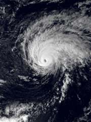
English: The VISSR instrument onboard the NOAA GOES-6 satellite captured this visible image of Hurricane Peke on September 27, 1987, at 03:15 UTC. At the time this image was captured, Peke was a Category 2 hurricane and had maximum sustained wind speeds of 100 mph (155 km/h). |
| Date | |
| Source | NOAA CLASS ( https://www.avl.class.noaa.gov/saa/products/welcome) |
| Author | The National Oceanic and Atmospheric Administration (NOAA) |
Licensing
This image is in the
public domain because it contains materials that originally came from the U.S.
National Oceanic and Atmospheric Administration, taken or made as part of an employee's official duties.
|
File history
Click on a date/time to view the file as it appeared at that time.
| Date/Time | Thumbnail | Dimensions | User | Comment | |
|---|---|---|---|---|---|
| current | 23:55, 25 December 2020 |
| 1,500 × 2,000 (4.02 MB) | CooperScience | Uploaded a work by The National Oceanic and Atmospheric Administration (NOAA) from NOAA CLASS (https://www.avl.class.noaa.gov/saa/products/welcome) with UploadWizard |
File usage
The following pages on the English Wikipedia use this file (pages on other projects are not listed):