Original file (2,880 × 1,800 pixels, file size: 1.18 MB, MIME type: image/jpeg)
| This is a file from the
Wikimedia Commons. Information from its
description page there is shown below. Commons is a freely licensed media file repository. You can help. |
Summary
| Description |
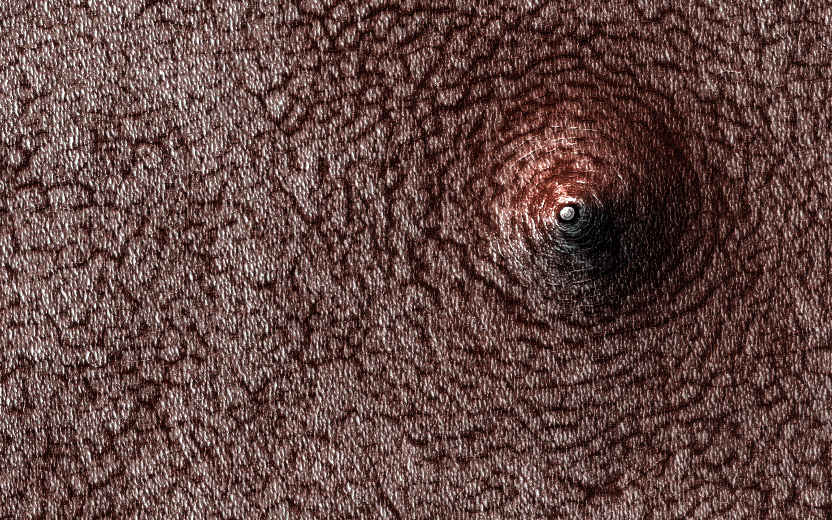
English: Mars - Collapse Pit - December 28, 2020 - uploaded April 27, 2021
PIA24614: Collapse Pit https://photojournal.jpl.nasa.gov/catalog/PIA24614 This image acquired on December 28, 2020 by NASA's Mars Reconnaissance Orbiter, shows a pit that has formed on the south polar layered deposits. Do you see a dome or a pit? Sometimes it is hard to tell! In this case, the answer is that we're looking at a pit, if the title didn't already give it away. Levity aside, we can tell this is a pit because we know what direction the sunlight is coming from and which side should be in shadow. This pit has formed on the south polar layered deposits. Why did it collapse? That is the real question to be answered. The map is projected here at a scale of 50 centimeters (19.7 inches) per pixel. (The original image scale is 49.6 centimeters [19.5 inches] per pixel [with 2 x 2 binning]; objects on the order of 149 centimeters [58.7 inches] across are resolved.) North is up. The University of Arizona, in Tucson, operates HiRISE, which was built by Ball Aerospace & Technologies Corp., in Boulder, Colorado. NASA's Jet Propulsion Laboratory, a division of Caltech in Pasadena, California, manages the Mars Reconnaissance Orbiter Project for NASA's Science Mission Directorate, Washington. |
| Date | |
| Source | https://photojournal.jpl.nasa.gov/jpeg/PIA24614.jpg |
| Author | NASA/JPL-Caltech/University of Arizona |
This image or video was catalogued by Jet Propulsion Laboratory of the United States
National Aeronautics and Space Administration (NASA) under Photo ID:
PIA24614. This tag does not indicate the copyright status of the attached work. A normal copyright tag is still required. See Commons:Licensing. Other languages:
|
Licensing
| This file is in the public domain in the United States because it was solely created by NASA. NASA copyright policy states that "NASA material is not protected by copyright unless noted". (See Template:PD-USGov, NASA copyright policy page or JPL Image Use Policy.) | ||
 |
Warnings:
|

|
This image has been assessed under the valued image criteria and is considered the most valued image on Commons within the scope: extraterrestrial collapse pits. You can see its nomination here. |
File history
Click on a date/time to view the file as it appeared at that time.
| Date/Time | Thumbnail | Dimensions | User | Comment | |
|---|---|---|---|---|---|
| current | 11:51, 29 April 2021 |
| 2,880 × 1,800 (1.18 MB) | Drbogdan | Uploaded a work by NASA/JPL-Caltech/University of Arizona from https://photojournal.jpl.nasa.gov/jpeg/PIA24614.jpg with UploadWizard |
File usage
Global file usage
The following other wikis use this file:
- Usage on zh.wikipedia.org