
Original file (1,024 × 1,024 pixels, file size: 252 KB, MIME type: image/jpeg)
| This is a file from the
Wikimedia Commons. Information from its
description page there is shown below. Commons is a freely licensed media file repository. You can help. |
Summary
| Description |
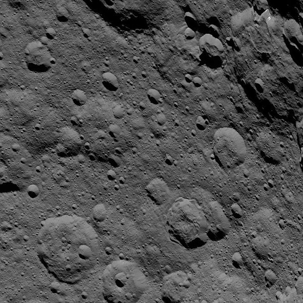
English: PIA20148: Dawn HAMO Image 85
http://photojournal.jpl.nasa.gov/catalog/PIA20148 This image of Ceres, taken by NASA's Dawn spacecraft, shows cratered terrain at high northern latitudes. Dawn acquired the view from an altitude of 918 miles (1,478 kilometers) during the mission's High Altitude Mapping Orbit (HAMO) phase on Oct. 20, 2015. Image resolution is 394 feet (120 meters) per pixel. Ghanan Crater, 42 miles (68 kilometers) in diameter, is seen at upper-right. A distinctive flow feature extends into the crater from its northern rim. The image is located at approximately 72 degrees north latitude, 8 degrees east longitude. Dawn's mission is managed by JPL for NASA's Science Mission Directorate in Washington. Dawn is a project of the directorate's Discovery Program, managed by NASA's Marshall Space Flight Center in Huntsville, Alabama. UCLA is responsible for overall Dawn mission science. Orbital ATK, Inc., in Dulles, Virginia, designed and built the spacecraft. The German Aerospace Center, the Max Planck Institute for Solar System Research, the Italian Space Agency and the Italian National Astrophysical Institute are international partners on the mission team. For a complete list of acknowledgments, see http://dawn.jpl.nasa.gov/mission. For more information about the Dawn mission, visit http://dawn.jpl.nasa.gov. |
| Date | |
| Source | http://photojournal.jpl.nasa.gov/jpeg/PIA20148.jpg |
| Author | NASA/JPL-Caltech/UCLA/MPS/DLR/IDA |
Licensing
| This file is in the public domain in the United States because it was solely created by NASA. NASA copyright policy states that "NASA material is not protected by copyright unless noted". (See Template:PD-USGov, NASA copyright policy page or JPL Image Use Policy.) | ||
 |
Warnings:
|
File history
Click on a date/time to view the file as it appeared at that time.
| Date/Time | Thumbnail | Dimensions | User | Comment | |
|---|---|---|---|---|---|
| current | 19:46, 5 January 2016 |
| 1,024 × 1,024 (252 KB) | Drbogdan | User created page with UploadWizard |
File usage
Global file usage
The following other wikis use this file:
- Usage on ro.wikipedia.org
- Usage on uk.wikipedia.org